The city of Priene, located in south-west Turkey near the Aegean sea, is justly famous as an unusually well-preserved example of a Late Classical—Hellenistic city plan. It was never an important town, however, and its population was small, perhaps only 4,000. Despite its size, the city managed to equip itself with the public buildings characteristic of Greek city-states, including those necessary for democratic government. In the late Hellenistic period, its prosperity faded and, to the great fortune of archaeologists, the buildings were never replaced. As a result of this modest destiny, Priene shows us an ancient Greek city in a comprehensive way that richer, much rebuilt centers such as Athens cannot (Figure 17.5).

Figure 17.5 City plan, Priene
The building history of Priene is striking, for the city occupied two different sites in the Meander River valley. Although the existence of the early town, founded by Greek emigrants in the Iron Age, is attested from literary sources and coins, the exact location has never been identified; it must lie buried deep in accumulated silt. Indeed, as the river carried eroded earth down from the hills, the shoreline was continually shifting westward, and the town found itself more and more inland. In the middle of the fourth century BC the citizens of Priene decided to move closer to the seacoast. Magnificently situated on a bluff overlooking the Meander River and, in the distance, the Aegean Sea, with a protecting mountain looming behind, this second Priene makes a dramatic impression on visitors.
With the river actively continuing to bear silt, even in their second location the people of Priene found themselves farther and farther from the sea, their economic prospects fading. A widespread destruction deposit indicates a damaging blow in the late second to early first centuries BC, possibly connected with the violent revolt of Mithridates VI, king of Pontus, against the Romans in 88—85 BC. Habitation dwindled, and the town would never recover.
The plan of the city refounded in the fourth century BC can be understood clearly both in overall scope and in details, thanks to excavations conducted by the German Archaeological Institute notably in 1895—98. The fortifications mark the perimeter, walls of neatly cut ashlar blocks that can still be followed for most of their length, tracing the curve of the bluff on which the city is located. In addition, the defense system incorporated the mountain behind. The layout of the town within the walls features streets at right angles in accordance with the principles of planning associated in the Greek world, at least, with the fifth century BC urbanist, Hippodamus of Miletus. Hippodamus left no writings; his work was commented on by various ancient writers, notably Aristotle in his book Politics. Hippodamus was described as having “invented the division of cities” and “cut up Peiraeus,” the port of Athens. These divisions were not only physical but also social. A city of ten thousand, Hippodamus proposed, should be divided into three classes (artisans, farmers, and warriors), its land into three parts (sacred, public — to provide food for the warriors — and private). The “cutting up” of Peiraeus appears to refer to physical division, with the finds of inscribed boundary stones from the fifth century BC indicating different planned districts. But Peiraeus has a varied topography; the grid plan was applied only to its flat central section, it seems, not to its hilly areas.
At Periene, as in Peiraeus and most other planned Greek cities, the Hippodamian rules are not scrupulously followed. The agora, for example, does not straddle precisely the axis of the main east-west street, and the stadium, carved into a restricted space on the lower hillside, could only fit on the diagonal. In addition, the city proper lies on sloping ground; this too necessitated adjustments. The east-west streets, more-or-less level, permitted wheeled vehicles, but the north—south paths were too steep; steps were often added. As in many Aegean villages before the advent of the motor car, foot traffic, animal and human, must have predominated.
The open-air rectangle of the agora or city center is neatly defined by stoas on all four sides. The precise geometric form of this planned public space, characteristic of newly founded cities in Greco-Roman antiquity, contrasts with the irregular, ever-changing urban centers that developed gradually over the centuries, such as the Athenian Agora. The stoas themselves are simple structures, but inside their sheltered colonnades a great variety of activities took place: legal affairs, government offices, shops, perhaps shrines, and simply meeting and chatting; and they always offered good shelter during a cold winter rain or on a hot summer day.
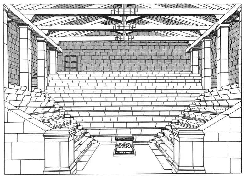
Stoas also served as architectural screens hiding diverse buildings behind; with their uniform line of columns, they preserved the harmonious appearance of the public square. Here at Priene, the eastern stoa masks a small temple, probably dedicated to Zeus; and behind the western stoa lay a meat and fish market. Nestled against the hill behind the impressive north or Sacred stoa stands one of Priene’s best preserved buildings, the Bouleuterion or Council Chamber (Figures 17.6 and 17.7). The bouleuterion looks like a small indoor theater. Almost square in outline, it has steeply rising rows of stone benches on three sides, seating for an estimated 640 people, and on the fourth side, between two doorways, a recess lined with stone benches for the presiding officials. In the center of the room stood a small altar used for the sacrifices performed at the beginning of each meeting. The wooden roof has not survived. Because of the width of the building, 14.3m, the roof needed the additional support of pillars set inside the room.

Figure 17.6 Bouleuterion, Priene
Below the agora on the side opposite the bouleuterion lie the gymnasium and the stadium, cut into the south slope of the bluff in the second century BC. Because of the steep terrain, the stadium has a truncated plan, with seating on the north (city) side only. Fragments of the stone starting line, an addition of the Roman period, still exist, with cuttings that once held an elaborate starting mechanism, a rig of posts and cords that assured a simultaneous start for all eight runners. The gymnasium is noteworthy for unusual features preserved in the rooms on the north side of the court. The central hall served as a schoolroom for boys, many of whom carved their names on the walls. Over 700 names can still be read; for example, “The place of Epikouros son of Pausanias.” Next to the lecture hall was a washroom. Stone basins placed on either side of the doorway served for rinsing feet, a row of basins along the rear walls of the room for hands and faces.
Up the hill from the bouleuterion one reaches the theater. Built early in the city’s existence, it preserves its Hellenistic Greek character despite some modifications in the Roman period (Figure 17.8). In Greek fashion as seen at Epidauros, the cavea is larger than a semicircle, although the rear section is truncated at the sides, and is separated from the skene by parodoi. But some features in this theater differ from Epidauros. Five stone armchairs, perhaps reserved for priests, line the orchestra. The stage building consists of two parts, a high raised platform in front, the proskene (proscenium), and an even taller portion behind. The facade below the proskene is decorated with twelve columns that mark off a series of doors and panels, an effective backdrop for Classical plays performed in the orchestra by the chorus and solo actors. In the post-Classical theatrical tradition, the chorus lost much of its importance. The prominence of the solo actors was emphasized by placing them on top, not in front, of the proskene. For all spectators except the dignitaries in the front row armchairs, the view would have been immeasurably improved.

To the west of the theater lie the remains of the Temple of Athena, the most important shrine of the city. Its terrace above the north-west corner of the agora dominates Priene, but only the foundations and five re-erected columns survive to indicate the temple’s original dimensions. The temple is Ionic, not surprising considering that the architect, Pytheos, denounced the Doric order with its intractable corner triglyph problem as incurably defective. The ground plan is standard, provided with the standard pronaos, cella, and opisthodomos; in contrast, the surrounding colonnade differs from the expected, consisting of only eleven columns on each of the long sides instead of the normal thirteen. The proportions of the temple were much admired, and indeed Pytheos wrote a book about them (which has not survived). The temple is also of note for its distinguished patron. Alexander the Great, when he passed through in 334 BC, offered to finance the construction in return for the privilege of making the dedication. The Prienians gratefully accepted.
Below the temple, the main street continues westward from the agora to the main residential area of the town. The paved street, which slopes gently downward, has a good-sized drain running down its center. Off it on either side lie the foundations of numerous houses. These discoveries, together with the Athenian houses (above, Chapter 16) and the roughly contemporaneous examples from Olynthos and Delos, give us a good picture of the home life of the solid citizen in ancient Greece.
As in other Greek cities, at Priene the houses consisted of a central courtyard lined by colonnaded porches and rooms behind (Figures 17.9 and 17.10). But here the rooms at the rear end of the court are emphasized: the roof line is higher, and consequently the columns of the porch are taller, more prominent. This architectural unit of a porch plus main room recalls the megaron of Bronze Age Trojan and Mycenaean architecture.
 World History


![The Battle of Britain [History of the Second World War 9]](/uploads/posts/2015-05/1432582012_1425485761_part-9.jpeg)