The great importance that the state placed on control of Nubia during the Middle Kingdom is seen in the series of Egyptian forts that were built there - and the organization required to man and supply them from Egypt. As reported in Egyptian texts, nomadic peoples of the Eastern Desert known as the Medjay posed a potential problem, but some of them were also employed as mercenaries in the forts. The C-Group peoples, who first came into Lower Nubia in the late Old Kingdom (phase la in the relative chronology of the C-Group), lived in areas where the Egyptians subsequently built several strategically placed forts. During the Middle Kingdom the C-Group continued to occupy Lower Nubia (phases Ib and Ila). While some C-Group burials have increasingly larger superstructures, such as David O’Connor demonstrates for Cemetery N at Aniba, C-Group burials did not become greatly differentiated until after the Middle Kingdom (phase IIb). In this phase a few burials have massive stone superstructures - up to 16 meters in diameter, sometimes with mud-brick chapels and vaulted burial chambers - and numerous imported grave goods. These monuments are symbolic of greater social and economic differences and probably the emergence of powerful chiefs when Egypt no longer controlled the region. The addition of mud-brick chapels exhibits an Egyptian influence in traditional C-Group mortuary practices.
From forts at Elephantine and probably Biga Island, on Egypt’s southern frontier (the First Cataract), Lower Nubia was reconquered in the early 12th Dynasty under Amenemhat I and Senusret I. Beginning with Senusret I’s reign a number of Nubian forts were built, some in areas where C-Group populations were concentrated, such as at Aniba, Dakka, Faras, and Buhen, which had first been used during the Old Kingdom. The forts at Ikkur and Kuban, on opposite banks of the Nile, protected river access to the gold mines of the Wadi Allaqi. With a large administrative complex, the fort at Kor near Buhen may have been a center for overland trade routes. On the east bank, the fort at Serra East was named “Repelling the Medjayu" which suggests that some Medjay posed a military threat there.
By Middle Kingdom times a powerful polity had developed farther up the Nile in the Kerma basin, to the south of the Third Cataract, and the presence of the Kerma kingdom
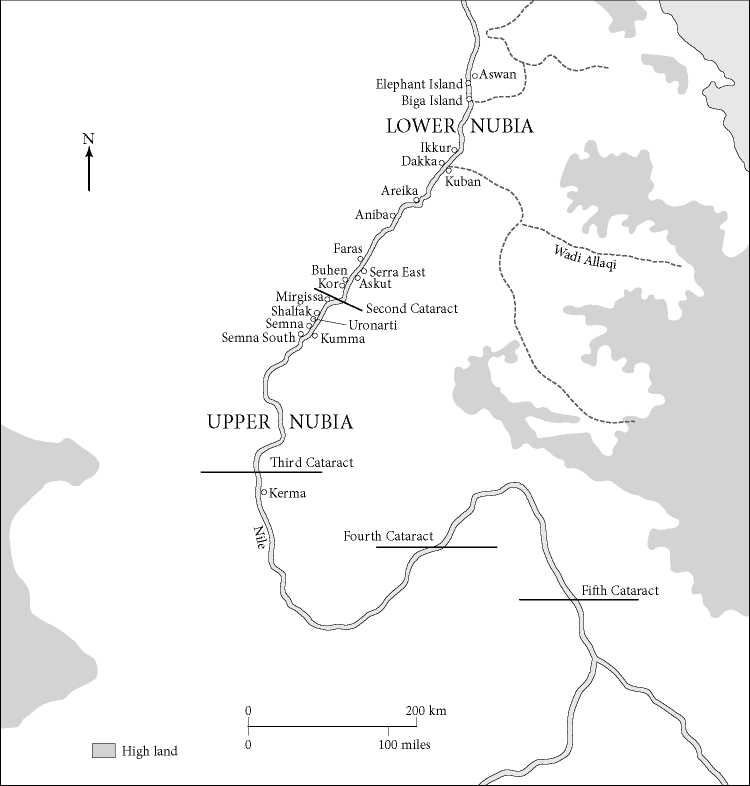
Map 7.2 Sites in Upper and Lower Nubia during the Middle Kingdom and Second Intermediate Period.
Explains the impetus for constructing the southernmost Egyptian forts in nubia. Through military campaigns, Senusret III pushed Egyptian control south and five forts were built within sight of each other as far as the new frontier of Semna, which dominated the rocky bluffs overlooking the southern end of the Second cataract region. older forts were also expanded or rebuilt. The largest of the new frontier forts was at Semna, with a fort across the river at Kumma, to the north of which was the island fort of uronarti with a large “palace” - possibly where the king would stay during military campaigns. Two more forts were built on the west bank at Semna South and Shalfak further north. Beginning at the Mirgissa fort, a mud-covered slip-way two kilometers long had been excavated to drag ships around the cataracts when there was low water.

Figure 7.11 Reconstruction of the 12th-Dynasty fort of Buhen, generated from a 3-D computer model originally created in 1993 by Bill riseman and updated by the Institute for the Visualization of History. Source: © 2014 Institute for the Visualization of History, Inc.
To conform to their natural setting, some forts could not be designed with rectangular walls. But the fort at Buhen (Figure 7.11), which was built along the river bank, did not have this problem and its inner citadel formed a huge rectangle, ca. 150 x 138 meters. Inside the citadel, which was better preserved on the north and west sides, rectangular buildings of the garrison were laid out in a grid along streets. In the northwest corner was a commander’s building with pillared halls, to the east of which were five long narrow galleries with columns in the center. The galleries are similar in size and design to what were possibly sleeping barracks in the 4th Dynasty royal complex that Mark Lehner has excavated at Giza (see 6.7). Buhen also had a temple, and there were probably many granaries. The citadel was fortified with a 5-meter-thick mud-brick wall with three gateways, one on the west and two facing the river. Towers were located along the west wall, at the gateway, and at the north and south ends.
In the 1960s Buhen was excavated by British archaeologist Walter Emery, who uncovered evidence of very sophisticated defensive architecture. At the base of the citadel walls was a lower walled rampart, with slits for archers. Below this was a dry moat cut over 3 meters deep into the bedrock with a sloping glacis on its outer side. The fort was designed to be defended by archers, and the dry moat and glacis were to protect the walls from tunneling or being undermined by siege devices. Beneath the northeast gate was a stone-lined passage that provided access to river water if the fort was under siege. Beyond the citadel, a thick outer defensive wall with another rock-cut moat and rampart spanned an area ca. 450 x 200
Meters. A cemetery was located along the western area enclosed by the great outer wall, and two towers flanked its massive gate.
Thus, during the Middle Kingdom 17 Egyptian forts (and numerous lookout points) were constructed along a ca. 400-kilometer stretch of the river in Lower Nubia, from Aswan to Semna. Built for military control of local peoples and Egypt’s frontier, the forts were a strong symbol of Egyptian authority to the Kerma kingdom farther upstream. Some forts were also centers for trade and exchange, especially of raw materials from the more distant south, and two forts controlled access to gold mining areas in the Wadi Allaqi. The forts allowed trade goods - as well as administrative communications - to flow north via the river to Egypt, and men and supplies to move south through Lower Nubia.
Like the state towns at Kahun and South Abydos, the Nubian forts were carefully planned and designed on a model with an interior grid of mud-brick buildings and streets. These planned state settlements also provide evidence of the huge redistributive system that reached its maximum during the reign of Senusret III. In Nubia, hundreds of men, and possibly also their families, lived in the forts and had to be supplied from Egypt. Granaries have been found in many of the forts, and Barry Kemp has estimated that the largest complex of granaries at Askut had a capacity of ca. 1,632 cubic meters, which could supply over 5,600 (minimum) annual ration units. The forts were probably supplied with more food than the minimum required to feed all of their inhabitants, however, and calculating the number of persons fed at any fort is problematic.
Maintaining these garrisons in Nubia would certainly have required a large, effective administrative system, both state and military, to acquire and/or manufacture, organize, transport, and redistribute food, goods, and materials, to areas with few local resources that were remote from Egypt. Hundreds, perhaps thousands, of men were needed to construct and maintain the forts, and serve as soldiers, sailors, scribes, and officials - an accomplishment as impressive in its organization as the construction of Khufu’s Giza pyramid.
British Egyptologist Harry S. Smith has argued that at the end of the 12th Dynasty a system of rotating military units for the garrisons in the Nubian forts shifted to permanent settlers. According to Stuart Tyson Smith (University of California, Santa Barbara), the archaeological record at Askut confirms this major change of organization, which helped to make the occupation of Lower Nubia more self-sufficient. Sealings of officials at Askut show that Lower Nubia remained under Egyptian control until the later 13 th Dynasty, and Egyptian pottery (Marl A and Marl C) found in late 13th-Dynasty contexts there demonstrates that goods were still being shipped from both Upper and Lower Egypt. At the end of the 13 th Dynasty, the descendants of the first Egyptian settlers in the Nubian forts remained there under the rule of the king of Kush.
 World History