Duns
Hill forts of the type described above are rare, although not entirely absent, in northern and western Scotland. Their place is taken, in part, by stone-built fortifications known as duns or ringforts. Dating from protohistoric time, these sites, of which about 350 are scattered down the western side of Scotland, including the Inner
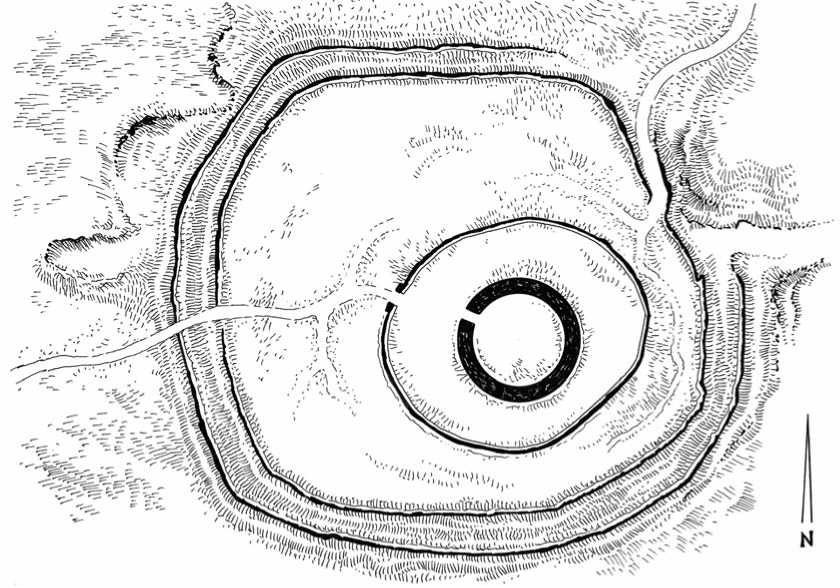
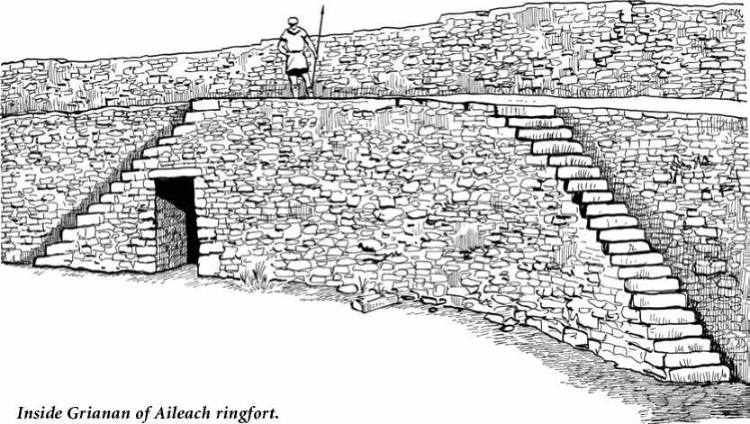
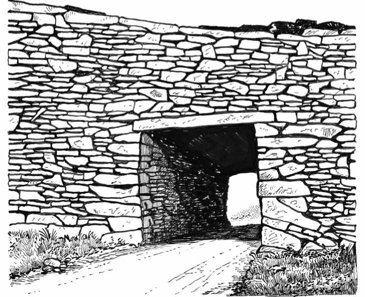
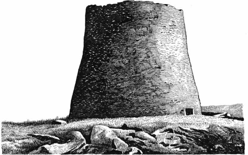
Situated 7 km west of Derry, Ireland, Grianan of Aileach is an impressive stone ringfort with surrounding earthworks perched on the summit of Greenan Mountain, allowing excellent views from the fort across Lough Swilly, Lough Foyle and the Inishowen Peninsula. Although heavily restored between 1874 and 1879, there are no doubts as to the antiquity of the site, as it is thought to have been built in the late Bronze Age or Iron Age. The ramparts of the hill fort have been eroded by time and only hints of their former stature remain, but recent accurate surveys show that there were two sets of ramparts, an inner and an outer. Both of the ramparts comprised a pair of banks and the total area enclosed by the outer boundary is about 5 acres. Grianan of Aileach is the only multivallate example to be found in the north of Ireland. The inner stone ringfort, also known as a cashel, is thought to have been built in the early years a. d. The cashel is of well-fitted dry-stacked stone construction and the the outer surface of the 5-meter-high walls has a graceful curved, or battered form. The interior of the structure today has a diameter of 23.6 m and is reached through a lintel-covered entrance passage 4.65 m long and 1.86 m high. The entrance passage originally had recesses let into each sidewall. The interior of the walls has three terraces, or walkways, which are reached by several inset stairways. Within the walls are two passages which extend almost to the entrance passage itself; they are accessed by two small doorways.
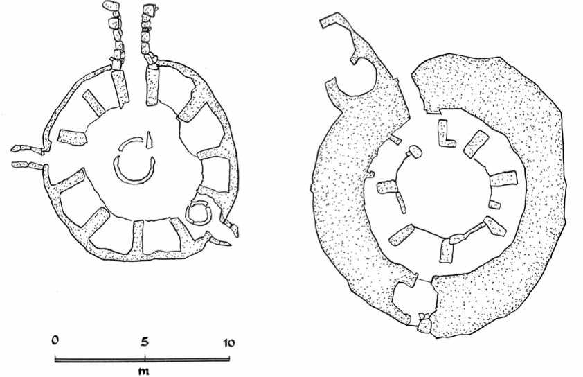
And Outer Hebrides islands, form a varied and heterogenous group of defended settlements. The main concentration of duns is from the northern end of Skye to the southern end of Kintyre. Also found in Ireland (and only a few in England), they differed from the rather large tribal hill forts by the fact that they consisted of a fairly small, usually oval or circular area up to about 60 feet in internal diameter enclosed by earth or stone ramparts. Ringforts were generally small, family farmsteads. They typically enclosed a group of homes and farming buildings with great variations in size: only one acre at Dunbeg and forty acres at Dun Ailinne. They were built by wealthy families who had both the need and the means to construct strong defenses. Ringforts had thus more of an economic function than a military one. Some were simple univallate sites enclosed by an earthbank or a stone wall and were built in lowlands, with or without an accompanying ditch. Others had multivallate defenses and were placed in dominant or commanding positions, on top or on the slopes of rounded glacial hills in lowland areas or backed up to bodies of water, which gave them a certain level of added security through better visibility as well as better draining soils. The rampart was usually 10 to 15 feet thick and consisted of a solid rubble core and well-built inner and outer face, often neatly coursed and with a noticeable batter or inward slope. Of course, particular attention was paid to the entrance passage, which narrowed in angular fashion to provide door checks, which were secured by a bar housed in sockets on either side. Access to the rampart was provided by a staircase in the thickness of the wall or by steps projecting from the inner face. There was sometimes a gallery running lengthwise along the wall at ground level, providing accommodations. There were also more elaborate timber galleries built against the inside of the wall, above ground level, in a number of duns. Some or all of the
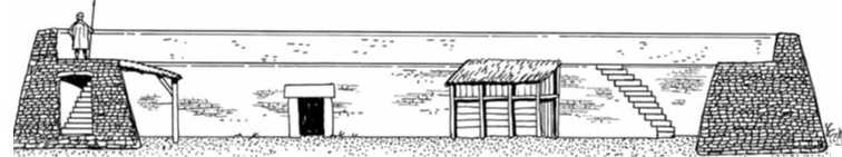
Conjectured reconstruction of the entrance to a dun

Above and below: Duns made of dry-stacked stone, which means that the stones were put together without what is known today as mortar. It has been suggested from the high quality of this type of work at certain dun sites that there may have been dry-stacked stone specialists. This would suggest a high level of craft specialization because dry masonry is certainly not a subsistence activity.
—I
3
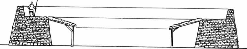
Cross-section of a one-story galleried dun

Two-story gallery
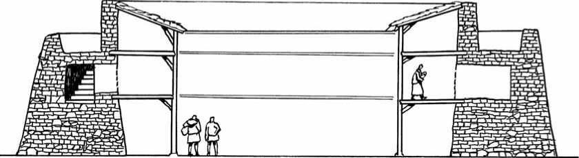
Three-story gallery
50
Meter-
Features just described appear in a number of small hill forts, and there is in fact no hard and fast dividing line between the types. A dun may appear to be a specialized form of hill fort, its main distinguishing feature being its small size. Variations from this standard pattern are generally the result of particular situations. On promontories, for example at Dunbeg Fort, where the defense was partly provided by cliffs or precipitous slopes, the fortifications were simply a straight or curving length of rampart facing the landward side. In the south and west of Ireland, stone ringforts (known
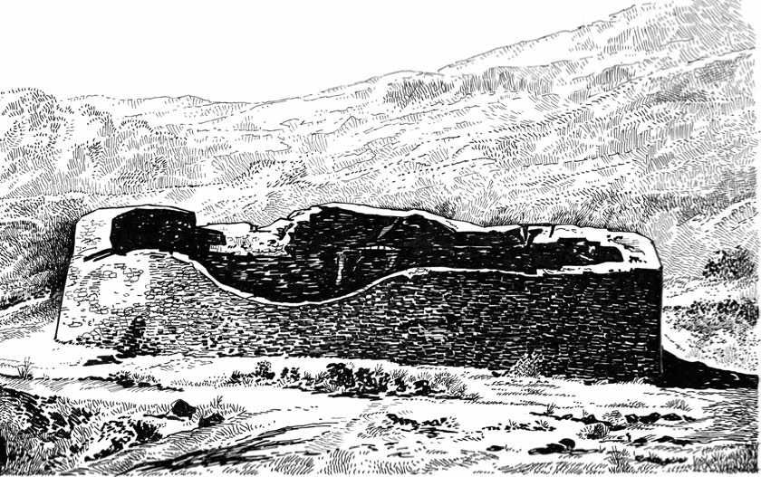
Ruins of Staigue ringfort, located inland of the Kenmare River in County Kerry about 3 km northeast of Castlecove, Ireland, was probably built in 500 b. c. and seems to have been occupied until a. d. 800. The dry-stacked stone walls of the circular settlement were 10 to 18 feet in height and 13 feet thick at the base. The diameter of the whole structure is 90 feet (30 m).
As cashels) are situated on the tops of steep-sided rocky outcrops (e. g., Leacanabuaile near Cahirciveen, or Carraig Aille near Lough Gur, Cashlaungar, county of Clare). Others were placed in sea-girth promontories.
Duns (particularly galleried duns) and brochs (see below) certainly have features in common, although this does not prove that one was derived from the other. They could well have developed in parallel from some source common to both.
Brochs and Wheelhouses
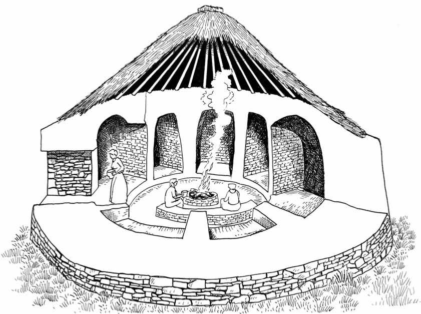
Away from lowland Britain and into the highland zone, notably in Scotland, the Iron Age settlement structures take on a different aspect and are not easy to connect directly with southern cultures or groups. The units of settlement are most often small, as appropriate to a harsher terrain, and the lowland timber buildings with earthen ramparts are largely replaced by structures with walls of stone, known as brochs. Brochs, one of the most distinctive types of monument to be found in Scotland and the Outer Hebrides, were massive dry-stacked stone towers built from 500 B. C. onward. The tendency to build upwards rather than outwards reflected a need for fortifications with a short perimeter that could be defended by many fewer people than a hill fort’s rampart or a dun’s stone wall.
There are about 500 brochs remaining in Scotland, mostly distributed in the Orkney, Hebrides, Northern Isles, and the north and west coasts of the Scottish Highlands. They had various functions, serving as an imposing home for the leading family of the area, a farmhouse, a central focus for the locality (in the same way a medieval castle did in later times), and as a demonstration of the strength and power of the individual who lived there. Within their enclosing area, they also were used as a place of possible refuge for the immediate community and its animals in extreme circumstances, notably during raids by Scandinavian Viking pirates.
The tower-like structures of the brochs are particularly distinctive, although they varied somewhat in design. A more compact and elevated version of the dun, brochs were circular in plan, generally between 12 and 19 m in diameter, with massively thick lower walls usually incorporating several chambers. Some were ground-galleried, not solid-based. Some were encircled by outlying walls. Some had guardrooms beside the constricted entrance, which was usually only 1.5 m high and 60 cm wide. This tunnel was sometimes surmounted by a chamber with holes in the floor, through which occupants could drop projectiles upon the cramped and crawl-
Mousa broch. Of all Scotland’s brochs, this one quite literally stands supreme: it rises to 13 m high and is both magnificent and awe-inspiring. The broch stands on the now uninhabited island of Mousa, a mile or so off the east coast of Shetland’s mainland. Today access is by a passenger ferryboat from Sandwich, some 15 miles south of Lerwick. At its base the broch is 15 m in diameter, but the interior is only 6 m in diameter. Within the huge thickness of the base of the walls are several chambers, probably used for storage, while at higher levels passages run between the inner and outer skins of the wall. Many mysteries remain about this impressive 2000-year-old tower. It is unclear whether, like many brochs, Mousa was the focus of a settlement that surrounded it or if it has always stood alone.
The Iron Age broch of Dun Mhulan was a large tower-like house built around 150 B. C., originally on an island within a freshwater loch, long before the open sea had broken through. It is 19 m across, with an east-facing doorway. The massively thick wall was built with an inner and outer face divided by a passage, which partly survives on one side. The broch’s original ground level is 1.8 m below the present day ground surface, and the flat slabs underfoot in the doorway are the roof of the original passage into the building. This passage led into the ground floor of the broch. There was also an upper floor, resting on a row of stones jutting out from the edge of the north wall. The upper room may have been the main living area of the broch, perhaps with storage space below, and there is uncertainty about the nature of the roof. A doorway in the south side led into a small oblong chamber (no longer visible) from which a stone staircase ascended clockwise within the wall. Subsidence soon after construction caused this staircase to crack and this part of the wall fell down within a few centuries. A small settlement grew up around Dun Mhulan in the early centuries A. D. It included a small house and two rectangular, stone-flagged barns. Around a. d. 400 the interior of the ruined broch was rebuilt as a roundhouse, with entry over the doorway’s roof slabs, past a small sideroom on the south side and into the main, circular room of the house. By the time the Vikings arrived, from 795 onwards, Dun Mhulan was abandoned.
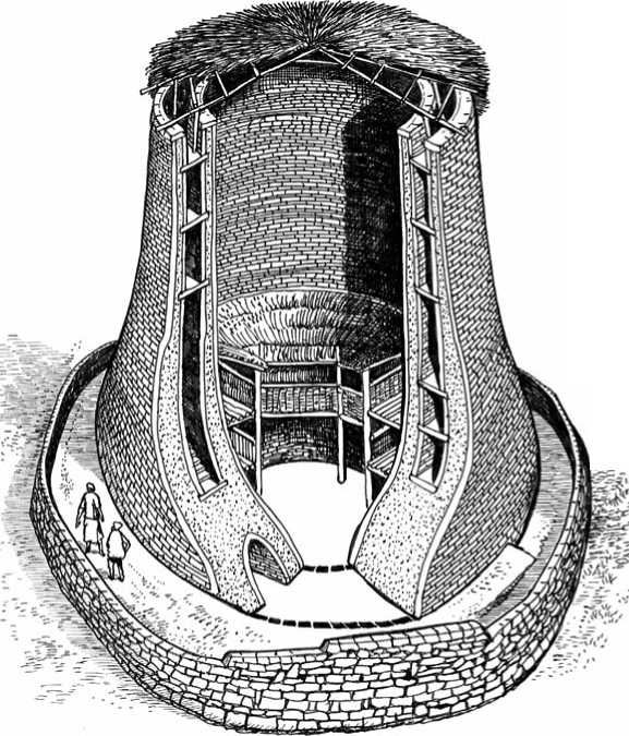
Ing attackers. If they were successful, attackers could only emerge one at a time, and thus were very vulnerable. The tunnel-like entrance shows that brochs were indeed places of refuge and not bases for offensive military operations. Above ground, floor-level brochs are built of two separate concentric walls, with a staircase and passageways between, tied together at intervals with stone slabs. The interior space of the broch comprised the mural chambers and main rooms, with storage on the ground floor, and the main living area above. Inevitably the uppermost parts have not been preserved, but brochs were likely to have been covered with a conical roof, although perhaps resting on the interior wallhead to allow a parapet walkway for observation and active defenses. But archaeologists have not determined if or how they were roofed, and therefore cannot gauge with precision their original height — perhaps between 30 and 50 feet.
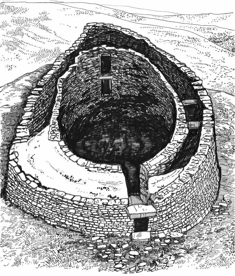
Carloway, or Dun Charlabhaigh, is a remarkably well-preserved broch in a stunning location overlooking Loch Roag on the west coast of Lewis, Scotland. Carloway was probably built sometime in the last century b. c. It would have served as an occasionally defensible residence for an extended family, complete with accommodation for animals at ground level. It would also have served as a visible statement of power and status in the local area. Inside the broch a number of chambers are accessible at ground level, an area which would probably have been used to house farm animals. The human residents would have lived 2 m higher, above wooden flooring. As in other brochs, stairs are fitted within the thickness of the walls, and there would probably have been several floors of accommodation beneath a conical roof. Carloway broch was severely damaged in the 16th century but its double-skinned construction is all the more clearly shown by its current ruinous condition.
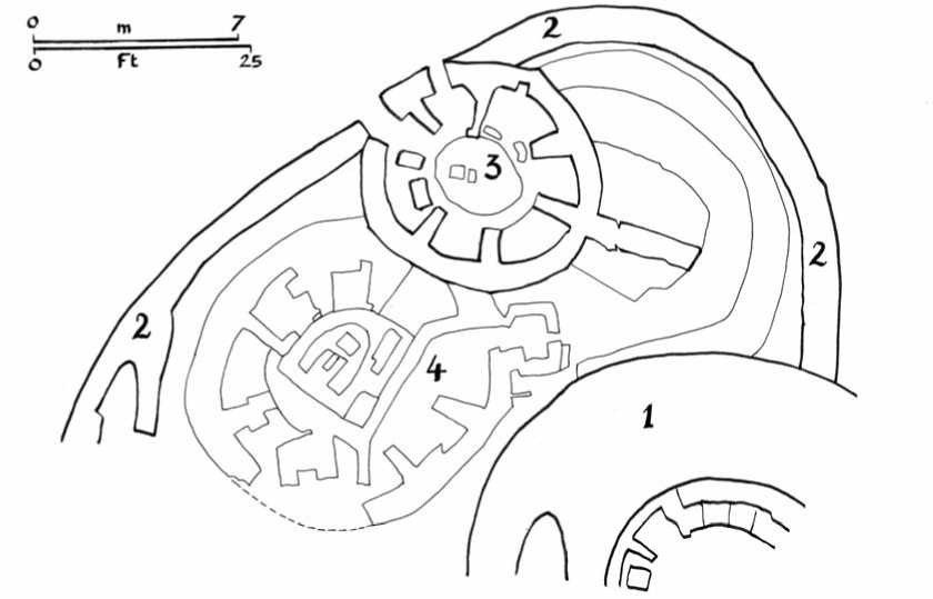
Jarlshof broch, situated in Shetland, had a diameter of 60 feet, walls 17 feet thick and an interior diameter of 25 feet. It had a roughly D-shaped walled courtyard on its west side, approximately 130 feet long and 75 feet wide, in which wheelhouses were eventually built. 1: Broch; 2: Enclosure of broch; 3 and 4: Wheelhouses later erected within the broch’s yard.
The best-preserved broch in the Outer Hebrides is at Dun Carloway on the west side of Lewis, standing in parts to 6.7 m high, although its original height may have been as much as 9 m. Other good examples are at Dun Cuier, Barra, Dun Mhulan in South Uist, Dun an Sticar in North Uist, and Dun Boranais and Dun Borgh in Lewis, although at some sites they only survive as a robbed-out footprint, as at Rubha’ an Teampuill, Harris.
Much of our knowledge comes from two brochs in the Outer Hebrides, which have been extensively although not completely excavated: Dun Mhulan in South Uist; and Beirgh Broch in Uig, Lewis. At Beirgh broch, however, all the deeply stratified excavated levels related to later re-occupation. The most complete broch in Scotland is on Mousa in Shetland, reaching 13 m.
Brochs can occupy a wide variety of settings, from hilltops to sheltered islands within lochs, and often their surrounding landscape has changed dramatically, such as in the case of Dun Mhulan, which started out on an island in a protected freshwater loch, and now lies on a storm-battered Atlantic shore. In the early centuries a. d., the classic way of life in many of the brochs seems to have come to an end, and smaller, humbler houses were built inside the shells of the grand, old brochs. Re-occupation generally continued until the eve of the Viking incursions at the end of the 8th century, after which the sites were commonly abandoned. It was (continued on page 49)
Wheelhouses. Left: Kilpheder (South Uist) Right: Clettraval (Northern Uist). Below: Cross-section of a wheelhouse (Conjectured reconstruction).
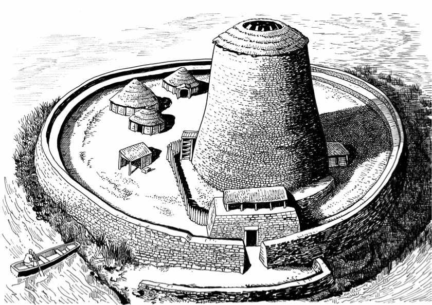
Clickhimin Broch (conjectured reconstruction) occupies what is today a promontory in the freshwater Clickimin Loch, on the outskirts of Lerwick. Originally, however, it was an island reached by boat, as denoted by the landing stage just outside the ringfort defenses on the south side. It was inhabited from c. 1000 b. c. to a. d. 500. Accommodation in the fort, pre-dating the broch, is represented by a low cellular structure of late Bronze Age or early Iron Age date. In the broch period the island was accessed by a stone causeway. Once through the ringfort entrance visitors were expected to duck through the blockhouse doorway. This has a door jamb and could be barred, and the structure is usually interpreted as a defensive tower with a fighting platform. It certainly had stairs to a second floor, but does not seem to have had much defensive functionality as it does not articulate with the ringfort. The essentially symbolic function of this structure is reinforced by the insertion in the later Iron Age of a shrine or small temple. Access to the broch itself is via an entrance on the western side, not immediately apparent from the main entrance. The broch entrance passage is long and low, with a blocked guard cell entrance on the right side just inside the door jamb. The design is usually interpreted as defensive but it also has the effect of making visitors bow as they enter the house, which may have been the most important intended consequence—a sign of respect. The tower is 65 feet in overall diameter, with walls 17 feet thick at the base and a central space 30 feet in diameter. There are cells in the wall’s thickness at ground level, but the main accommodation would have been in the circular central space that was roofed. In fact the prestigious accommodation was probably on the first floor, which must have been reached by an internal ladder or stair. The stairs both start at the first rather than ground floor level. As with many brochs, they ascend in a clockwise/sunwise direction. Over the centuries of occupation debris gradually raised the ground surface and the structure ceased to be an impressive tower, becoming more of a settlement mound. However, the site evidently remained prestigious.
(continued from page 46) not uncommon in the later Middle Ages, however, for the broch shells to once more become the residences of local chieftains.
Brochs are only one type in an impressive range of related buildings. Another version of the same theme is the wheelhouse, unique so far to the Outer Hebrides and Shetland. A total of 62 sites have been identified in the Northern and Western Isles, and on the north coast of Caithness and Sutherland. The wheelhouse, sometimes referred to as an “aisled roundhouse,” takes its name from the radial piers inside the circular stone wall, probably designed to support the roof structure. The interior was divided by a number of stone piers, arranged like the spokes of a wheel. The chambers thus created around the wall of the house were each roofed with a small, corbelled stone dome, and only the central, open area over the earth needed to be spanned with scarce timber, which would be covered over with turf. Wheel-houses were adapted for the Hebridean environment; they could be built as subterranean structures in sand or machair coastal areas with only the roof projecting above the ground, the small doorway giving little clue to the spacious house within, which might be from 4 to 10 m in diameter and about 6 m high. Wheelhouses could be built as free-standing structures, such as on the moorland where it was difficult to dig down. In those cases, a thick blanket of midden material was built against the outer wall. Wheelhouses, however, were lower and much less massive than brochs, and were probably farmhouses or dwellings, although many sites incorporate animal burials beneath the floor, tending to support the hypothesis that the primary purpose of these buildings was ritualistic. The highly restricted nature of their geographical locations suggests that they may have been contained within a political or cultural frontier of some kind. The co-incidence of their arrival and departure being associated with the period of Roman influence in Scotland is a matter of ongoing debate.
In the Northern Isles many wheelhouses are often found associated with brochs, the former taking advantage of the strong thick shell of the latter. At Clickhimin, a wheelhouse was built inside the disused broch, and at Jarlshof, also in the Shetland, wheelhouses were inserted into the broch courtyard. No sites in the west have such an association, an as yet unresolved enigma.
The material culture associated with the brochs and wheelhouses has local elements as well as those derived ultimately from southern Britain. Like Ireland, the north of Scotland lay beyond the frontier of Roman Britain, and the local Iron Age substantially outlasted the Roman occupation of Britain. The Scottish and Irish Iron Ages must be regarded as loose and rather remote variants of that combination of native and intrusive elements. Even the term “pre-Roman Iron Age” loses meaning in these areas. However, in spite of their elaborate structure, broch towers appear to have had a relatively short history. By c. a. d. 80-100 many of them seem to have gone out of use, while open settlements developed around their remains. The less elaborate duns may have persisted somewhat longer, as they were less specialized and more easily adaptable to peaceful activities.
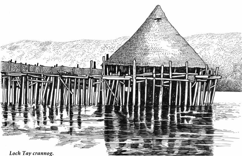
Loch Tay crannog.
Crannog
The term crannog refers to small artificial islands, which can be found in the majority of Scotland’s lochs and inland waters. The name is derived from the Irish word crann, meaning a tree. Originally the term may have been applied to the timber palisades that surrounded such sites, the timber buildings within them, or the timber foundations on which they were erected. The same name is used in Scotland, where similar sites occur. These lake villages on small islands—it is believed — were dwellings of prominent families or groups of families and the crannog also served as a refuge in times of attack. Most crannogs are to some extent artificial. This means that it has taken a certain amount of human activity to create them. In some cases, small islands or natural bedrock outcrops were only slightly enlarged, requiring relatively less effort. In other cases, crannogs were created from scratch by piling up vast amounts of material on the loch bed or in a marshy area in a bog. This obviously required substantial effort and considerable time. Regardless of the effort the product is always very similar — a small island, its surface protruding above the water, which owes its existence to human activity. Other features also found on crannogs include vertical wooden piles set into the bed of the lake or river, middens of discarded domestic waste, and sometimes a small harbor and jetties. Access to the crannog was normally by boat but when times became more settled, causeways or bridges were used. Although lake villages and crannogs may not have been of military intent originally, their very location must have made them difficult to approach, so that they became defensive places of refuge in times of crisis. Crannogs had a vari-
Ety of forms. Most were circular or oval, but all differed greatly in size. Average surface diameters range between 15 and 30 m, although there were notable exceptions both larger and smaller. The materials used to build crannogs also varied throughout Scotland. Crannogs found in the Hebrides seem to have been built primarily of stone, whereas those found in the mainland were predominantly built of wood. Most of this variation has been ascribed to differences in local environments. Obviously people used materials which were easy to come by or immediately at hand. Evidence suggests that crannogs have been used as habitation sites for a period longer than any other type of structure in Scotland’s history. Archaeological excavations have shown that crannogs were used during various periods ranging from the Neolithic (4000-2000 B. C.), the Bronze Age (c. 2000-500 B. C.), the Iron Age and Roman times. Literary evidence indicates that crannogs were still being used in remote areas of Scotland until the seventeenth century. This extensive time range makes it hard to know when a particular crannog was in use. Crannogs offer an unparalleled opportunity to recover information about Scotland’s past. Because Scotland’s lochs are so cold and relatively bacteria-free, organic materials such as wood, seeds and plant fiber are often well preserved. Such preservation helps archaeologists piece together what life on a crannog was actually like, in a way that cannot be achieved on dryland sites.
A few lake villages also existed in England, for example at Glastonbury, where a settlement was reclaimed in bogs and marshes, while farmers raised crops on high ground in the area. Worthy of mention is the Craggaunowen crannog, situated near Kilmurry, about 10 miles (16 km) from Ennis, county of Clare, in southern Ireland. This is a full-scale reconstruction of a crannog in its typical lake setting. Inside the crannog are several thatched roundhouses of wattles and mud surrounded by a protective fence. A gatetower stands over the entrance and a causeway connects the island to the mainland. The site is actually an archaeological open-air museum centered around a 16th-century towerhouse. A park of 50 acres of woodland with a picturesque lake is host to several examples of early historic places. Next to the crannog there is a small ringfort; a Bronze Age cooking and industrial site; a dolmen (Neolithic portal tomb); a standing stone; and a reconstruction of a leather hulled boat that is reputed to have been sailed by Saint Brendan from Ireland to Newfoundland in Canada in the mid-6th century A. d. Another reconstruction is the Loch Tay crannog at Kenmore, Perthshire, Scotland, based on the excavation evidence from a 2,600-year-old site.
 World History