The Roman conquest of A. D. 43 marked the introduction to Britain of a whole new range of fortifications, quite different from the hill forts, duns and brochs of the previous Celtic period. As the conquest progressed, Celtic strongholds were gradually reduced. They were sometimes re-used but generally new fortifications were built by the conquerors. As we have just seen, these new fortified works were made by an efficient, highly organized, well-disciplined army of professionals who constructed fortifications according to standard patterns. No matter where in the Roman Empire, fortifications (but also urban organization, bath-houses, amphitheaters, arenas, official buildings, religious temples, and roads) tended to follow a regular uniformity. Although there were indeed many variations from site to site, and from land to land, general patterns and regular designs were endlessly repeated throughout the empire. For fortifications, the basic shape was a rectangle with rounded corners, often described by archaeologists as a playing-card form. This basic Roman military enclosure was represented in several main types, all of which were seen in Roman Britain: the temporary or semi-permanent (tented) camp; the legionary fortress; and the fort. Other more or less standardized works included fortlets and watchtowers, frontier works and lines, coastal forts, and urban fortification.
Temporary and Semi-Permanent Camps
The Romans were not the first army to build defended camps on the march, but they took the construction of temporary defense works to the point of obsession. It
Was indeed standard practice for Roman units in hostile territory to construct a defensive earth wall around every castellum (non-permanent camp, plural castella), even for a single night’s bivouac. The playing-card form was always the goal, but it could happen that the engineers and surveyors, whose mission it was to mark out the castellum in advance of the main body of the legion, had to make do with the natural surroundings. Castella diverging from the standard pattern thus existed, but a Roman army’s camp on the march was never untidy or totally irregular in shape, and it always displayed an impression of order and discipline. Surveyors and engineers, men with plenty of experience who had an eye for the ground, always attempted to establish the camp on a slightly sloping hillside, a place well-drained and fairly open, if possible with easy access to water, firewood and fodder for the animals. Once such a place had been selected, the survey party would sometimes flatten the ground and before starting the ditch and wall construction, an agrimensor (land surveyor) would draw the locations of the streets and of the wall, beginning from the center of the field, by staking out the center line of the camp (decumanus maximus) crossed by its axis (cardo maximus). These two lines formed the basis of a broad pathway bisecting the camp, the via principalis about 30 m wide. The corners of the square or rectangular camp were marked out, as well as the various strigae (spaces where tents were to be erected). As soon as the main body of the army arrived, the legionaries took off their weapons and equipment, grasped their spades and started to dig a fossa (ditch) generally 6 feet wide and 3 feet deep, with the deblais (excavated soils) thrown inwards to form a remblais of similar size, which constituted the agger (rampart). Wooden stakes called sudes— of which one or two were carried along by each legionary, probably for this purpose (or locally felled trees cut into stakes) — were driven into the top of the wall to constitute a vallum (palisade). Strictly speaking a vallum designated only a single stake in the palisade, but in due course it came to designate a palisade and eventually the rampart itself. According to its importance and size, such a tented camp had four or six entrances all guarded by sentries, and the internal space was occupied by troops’ tents, commanders’ and officers’ tents, granaries, workshops, cavalry quarters and so forth. Entrances were defended by a titulus, a free-standing length of bank and ditch constructed directly in front of the opening in order to prevent a direct approach. An alternative disposition was the clav-icula, a curving extension of the wall projecting inwards or outwards that provided a simple measure of security for troops under canvas. The standard disposition of the Roman camp was very practical. Indeed once a soldier was inside, he always knew where everything was whether it was, a temporary camp with tents or a permanent fort with buildings.
Of course the size of a temporary camp varied according to the unit it had to house. A legion of 5,000-6,000 men required a camp about 900 feet square. However, where large-scale operations were carried out, larger camps were required. For example, the camp at Featherwood West (Northumbria), was about 1,600 feet by 1,100 feet and could accommodate two legions. The camp at Raedikes (Grampian, southwest of Aberdeen) had an irregular outline: it was approximately 2,620 feet by
1,750 feet (800 by 530 m), covered an area of about 110 acres (44.5 hectares) and could house five legions. The northern and eastern defensive ditch was quite substantial, around 15 feet across and about 7 feet deep (4.6 by 2.1 m), and the rest of the perimeter was markedly less significant. In the same region, there were similarly sized temporary marching camps at Normandikes (106 acres), Kintore (110 acres), Ythan Wells (111 acres) and Muiryfold (109 acres). There were naturally smaller camps for small units, namely for cohorts of 480 men. There were also temporary camps that were built by troops in peacetime as part of their training so that on actual active service legionaries would have the experience necessary to erect a fortified overnight bivouac as a matter of routine. There is no doubt that the Romans were obsessed with digging, perhaps partly to keep the men in physical shape, and partly to give them something to do, as boredom could undermine discipline.
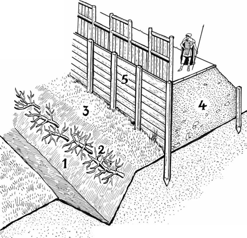
Cross-section Roman earth and timber rampart. 1: V-shaped ditch; 2: Cippe (sharpened tree branches); 3: Berm; 4: Rampart and wallwalk; 5: Timber wall with parapet.

Wattlework parapet. The lorica, also called the parapet or breastwork, was a man-high defensive screen, often fitted with open parts, called crenels or pinnea (1), and standing parts, named merlons (2), placed along the upper outer edge of a wall (3), and protecting the wallwalk (4). The parapet could be an earth bank or a palisade (stakes) or made of wattle (interwoven twigs).
In addition there were semi-temporary camps, which were occupied for longer than one night, or which acted as supply bases for a campaign. In the latter case not all of the space within the camp was used to accommodate troops, but instead featured stores and supplies for units on the move. Semi-permanent camps were built according to the same playing-card design, but they had slightly more elaborate defenses as more time was available. The tents were also replaced with wattle-and-daube, thatched-roofed timber huts for more comfort, particularly when the camp was to be occupied over the winter. Good examples of semi-permanent camps have been discovered at Chew Green in Northumbria (19 acres) and Cawthorn in Yorshire ( 5.25 acres). Semi-permanent camps were also used in the case of a siege, and then were part of siege works, for example the camps of Dumfries and Galloway, built during the siege of the Celtic hill fort of Birrenswark. These supply bases and camps were often only maintained for a short period before the military unit would move on to another location. However, if the site was suitable, temporary and semi-temporary camps and supply bases could become permanent camps used for more or less long
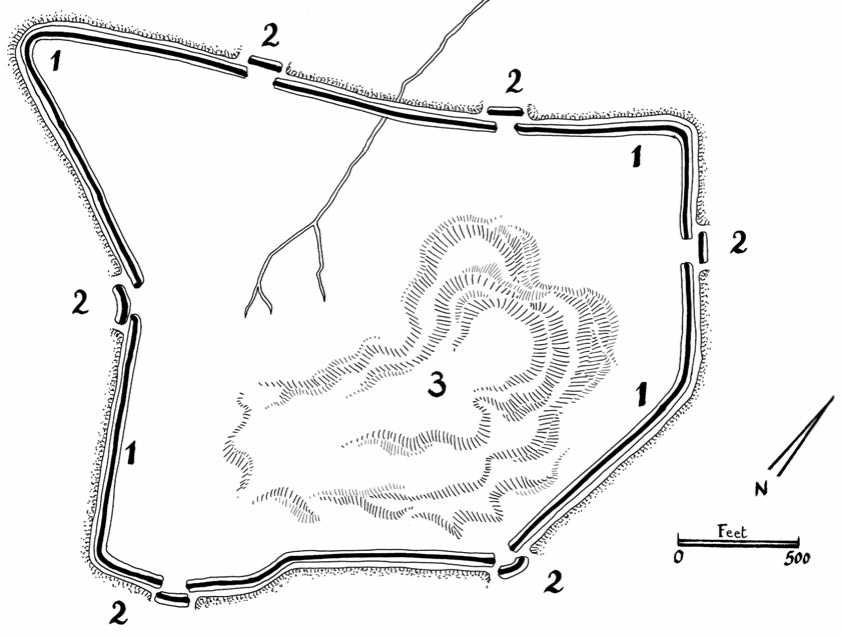
Raedikes: 1: Enclosure; 2: Gates with titulus; 3: Garney Hill (also known as Garrison Hill).
Term, when occupation duty replaced active offensive. Whether originating from a semi-permanent camp or a totally new foundation, the structure remained the same, but the defenses of the semi-permanent camps were more elaborate. The surrounding ditch was deeper and the earth wall was higher, up to 8 feet, and up to 20 feet wide, with a proper timber palisade and rampart walk at the top. Tituli and clavic-ulae were stronger, and small wooden watchtowers and obstacles added. When the camp became a permanently occupied position, earth ramparts and timber towers were replaced with stone walls, gatehouses and masonry towers, and all buildings and structures inside the camp were equally built with stone.
Legionary Fortresses
Once the initial conquest of Britain was achieved three legions were stationed in camps called legionary fortresses. The term fortress suggests a formidable defensive structure, something like a medieval castle with high walls and formidable towers, or a fort bristling with weapons and outworks, but in fact the defensive capacity of the legionary fortresses was not particularly impressive, mainly because the fortresses were not intended for passive defense. As a rule, Roman soldiers, when
Attacked, would not wait inside their walls, but instead would sally en force. Relying on their mobility, strength and discipline, they would rather fight and defeat enemies on the open field. The legionary fortresses were therefore more fortified barracks than defensive structures. Although they had to secure against the possibility of a surprise attack, they were primarily designed to provide permanent and tolerably comfortable quarters for the garrisons. The term “legionary fortress” is probably now too well established by scholars, experts and archaeologists to be changed, but the offensive rather than defensive role of these legionary bases should always be kept in mind. After the reign of Emperor Domitian (a. d. 81-96), legionary fortresses were reduced in size to approximately 10-15 hectares, and accommodated only one legion, or they were even smaller and housed only one or more cohorts. A legionary fortress included a number of buildings of more or less standardized design.
The principia or headquarters block was the administrative and spiritual center of the fortress. It faced onto the junction of the two main roads through the fort, often with a portico in front, perhaps carrying an inscription recording construction or renovation. The entrance to the principia proper opened onto a colonnaded courtyard. The presence of altars and tribunalia (saluting bases) indicate that ceremonies and parades must have been customarily held there. Ranges of rooms sometimes flanked this courtyard, perhaps serving as stores, especially for weapons (armamentaria) or workshops. Behind the courtyard stood the covered crosshall or basilica — a multi-purpose government building. After the Roman Empire became officially Christian, the term basilica came by extension to specifically refer to a large church. The basilica, with its two rows of massive columns flanked by aisles, probably looked like its archictectural successor: the Norman church. It often rose above the courtyard portico and the rooms to its rear, so that clerestory windows could admit light. The whole building was of monumental proportions, dwarfing the barrack blocks and most of the other adjacent constructions. The crosshall at Chester, for example, was about 240 feet long and 80 feet in width; the span of the nave was 40 feet and each aisle 20 feet. It would have been possible to assemble the bulk of the legion here, providing the soldiers stood shoulder to schoulder, and the commander or a visiting dignitary could have spoken to them, read an order of the day or issued special instructions. These assemblies may have been associated with the legionary shrine that stood in the center. The regimental shrine (called the sacellum or aedes) was the symbolic heart of the fort, where the standards, silver eagles, flags and emblems were kept. At the west end of the crosshall was a dais (tribunal), from which the garrison commander could preside at meetings or ceremonies and dispense justice. To the rear of the basilica were smaller administrative rooms and offices where the administration of the legion was carried out, correspondence was received, answered and filed, accounts were kept by the cerasii (administrators), and the librarii (clerks) and the exactores (accountants) worked out the many deductions from the soldiers’ pay.
The praetorium (commander’s residence) was a building almost as large as the principia, and was usually adjacent to it, either along the via principalis or the via
Quintana. It reflected the difference in class and status between officers and the rank and file. The fort prefect and his household had the best appointments and most spacious of all the accommodation, showing not only his military senior rank but also his superior social status as a member of the equestrian class. The praetorium, based on Roman townhouses in the Mediterranean, of the type preserved in Pompeii, for example, was composed of a range of heated rooms around a courtyard, sometimes including a private bath, offering the commanding officer a comfortable private space removed from the fort’s bustle. The senior officers or tribunes’ houses were smaller versions of the above.
The valetudinarium was the hospital where the sick and wounded could be segregated and treated. It comprised a range of wards around a central courtyard. At the entrance was a large reception hall and at the end an operating theater with running water. Sick and wounded soldiers were attended to by a variety of medical personnel. Each regiment had its doctor (medicus ordinariu), a pharmacist (seplasiarius), medical orderlies (medeci), and dressers (capsarii). Knowledge of medicines and drugs was elementary and highly empirical. Nevertheless, natural antiseptics such as pitch and turpentine were used and much employ was made of herbal lore which has, regrettably, been lost. A number of ancient treatises on medicine and surgery have survived, which throw much light on methods used by the Romans. In wartime, for the army doctors the commonest treatments were the extraction of foreign bodies and amputations.
Horrea (granaries, food and supply stores) were essential buildings ensuring the soldiers’ effectiveness as a fighting force and preventing any discontent. Their size and capacity were calculated for adequate provisioning of the soldiers housed in the fort. Granaries generally could store two years’ supply of grain. It was vital that the basic food supplies should be given maximum protection to ensure the smallest possible loss. The worst danger was fire, and therefore granaries were solidly constructed, and usually placed near the center of the fortress to be as far as possible from enemy incendiary missiles. Often built in pairs, their floors were raised on wooden posts or stone walls to allow air to circulate beneath in order to keep the grain, as well as other foodstuffs, cool and dry. External walls were normally massively built and buttressed to withstand the lateral pressure of the stored grain (although it remains uncertain whether the grain was stored in bulk or in barrels and also if other kinds of food, such as meat, were housed there as well) and to support the tiled roof. This was given a large overhang, so that the rainwater was carried well clear of the building, and this also offered greater shade from the sun’s heat in summer. Slots pierced the external walls to assist ventilation.
Barrack blocks took up much of the space within a fort. Their numbers, size and type depended on the garrison’s size and composition. The narrow buildings (on average 10 m wide and 40-50 m long) housed a centuria (80 infantrymen) or a turma (32 cavalrymen). Arranged in pairs, and placed back to back, forming a complete striga (allotted space in a fort) with little space separating them from one another, the rather gloomy barracks included a series of paired rooms (contubernia), as well
As the living and storage space for ordinary soldiers. Eight men occupied each room. Its name, the papilio, was the same as that of the folding leather tent which sheltered soldiers on campaign and bivouac. There were bunk beds (with straw mattresses) and lockers, shelves and pits for storage. Hearths provided light and heat for warmth and cooking, since there were no central canteens. Floors were of beaten earth, or clay, perhaps carpeted with bracken or straw or occasionally covered with flagging. Often a verandah ran the full length of the barrack. Communal latrines were installed outside the barrack. Living conditions must have been pretty crowded, as the eight legionaries also shared their room with wives, comcubines and children, and some soldiers may also have owned slaves. However given the likely difference between the strength of the unit on paper and its actual strength, barracks were not always fully occupied and more space was generally available.
At the end of the long barrack block were the officers’ accommodations, separated by a stone wall from the soldiers’ contubernia. The accommodation for the centurions included several rooms grouped around a central corridor. Often this block was wider than the rest of the barrack. Stone flagged floors, separate drainage, latrines and washplaces, glazed windows and plastered walls made these rooms more comfortable as well as more spacious than the rank and file’s. These quarters may have been shared with NCOs (junior officers). In cavalry barracks two turmae of 32 men each were assigned to each block. Horses were sometimes stabled in separate blocks, long narrow buildings with an interior drain running them of the building to remove waste. Drainage (sewers) and fresh water supply (springs, cisterns and wells) were very important features, closely associated with the health of the army, and the Roman military engineers always went to considerable lengths to see that both were adequate.
Fabrica (workshops) were built for engineers and practitioners of several craft, including builders, plumbers, leather-workers, smiths and weapon-smiths, carpenters and cartwrights. These fabrica were varied in shape and form, sometimes buildings around a courtyard, sometimes included as the service wing of the praetorium.
Beyond the fort too, the landscape was likely to be dotted with the signs of legionaries’ industry, such as kilns for pottery, bricks and lime burning, stone quarries, annexed spaces providing additional accommodation for soldiers and animals, parade and training grounds, and civilian settlements. Other extramural buildings included a bathhouse, amphitheater, and cemetery. The baths were housed in a building with specialized functions. They were shared with one’s colleagues and involved physical exercise, massage and indoor games, and were in fact a social club where one normally spent some time, stripping off the cares of daily life as well as its toil and sweat. Roman bathing (a mix between the Scandinavian sauna and the Turkish bath) was encouraged by the army since personal hygiene and social relaxation were important factors in the physical and mental health of the soldiers. The baths were placed outside the fort for two good reasons. First, the furnaces presented a serious fire hazard, and second, units on the move spending the night under the shelter of the fort generally pitched their tents in the annex and could make use of the bathhouse independently of the usual garrison.
The amphitheater was a large open arena, oval in plan, with a massive, heavily butressed outer wall which supported tiers of seats. At Chester the structure stood outside the southeast corner of the fortress and was about 300 by 350 feet with an outer wall 8 feet thick. The amphitheater was designed to accommodate the full garrison for religious celebrations, military parades and commemorations, training and tactical demonstrations, and games associated with gladiator combat and wild beast shows.
Under their law, the Romans were not permitted to bury their dead inside towns or military fortresses, so it was customary to establish the cemeteries along the roads entering the fortress. Both cremation and burial were practiced. The former was universal in the first century but gradually gave place to the latter until that, in turn, was more popular by the late second century.
In the early years of the occupation of Britain legionary fortresses were established at Lincoln and Gloucester, later at York, Chester and Caerleon, and another at Inchtuthil north of Perth in Scotland.
Inchtuthil fortress, located on an isolated plateau, was built in a. d. 83 and abandoned in A. D. 86 as it was probably too far advanced in hostile land. It was occupied for only three years by Legio XX Valeria Vitrix. It featured a 13-feet-thick earth wall (later with stone facing), with a ditch 20 feet wide and 7 feet deep in front. It had four gateways consisting of timber-built flanking towers. Nearly square in plan (1,565 by 1,529 feet), the large fortified enceinte enclosed a perimeter of 53 acres (21 hectares). The space inside was divided into quarters for nearly 6,000 men, stores, a military hospital, a bathhouse, workshops, a drill hall, and granaries and supply stores, as well as barracks and stables for a cavalry unit in the classic Roman military fashion.
The fortress of Lincoln, occupied only for 20 or 30 years in the early period of the conquest, consisted of a rectangular earth wall revetted with timber, enclosing an area of 42 acres. In a. d. 71, Lincoln was abandoned as a legionary fortress and became a colonia for retired emeriti (veterans), and the IXth legion left Lincoln in order to subdue the Celtic tribe of Brigantes in northern England. For this purpose a new fortress was founded at Eburacum (York), which remained one of the several permanent bases during the centuries of the Roman occupation. The legionary fortress of York measured 1,590 feet by 1,370 feet. Originally an earth and timber work, it was fortified with a stone wall and an earth bank in a. d. 107-8. In c. a. d. 300 the enclosure was reinforced with eight large projecting towers. The inside of the fortress included a stone-built headquarters, four large barrack blocks, and the usual service buildings as described above.
The legionary fortress of Chester, created in c. a. d. 78, measured some 1,950 feet by 1,360 feet and covered 56 acres. It housed infantry and cavalry, but also some naval personnel for operation on the River Dee. The internal buildings included five groups of barrack blocks, a headquarters, granaries, a bathhouse and an amphitheater.
Like Lincoln, the legionary fortress of Glevum (Gloucester) was transformed into a colonia in c. a. d. 64-5, and its garrison was transferred to a new site at Isca

Outline of Roman camps. The shape of a Roman fort was similar to a playing card—at least whenever possible—with an entrance on each side. Inside the fort there were two main streets that divided the camp. The via praetoria led from the front gate to the headquarters building (principia) in the center of the fort. The via principalis joined the two side gates and passed in front of the principia. The commanding officer’s house (praetorium) was next to the headquarters building, and the rest of the fort was divided into strigae filled with rows of barracks, workshops and stores. Left: Regularly-designed legionary fortress (based on Chester). Right: Irregularly-shaped marching camp (based on Featherwood West, Northumberland).
(Caerleon near Cardiff). Originally defended by a clay wall revetted with timber, Gloucester later included a 5-feet-thick stone wall with a ditch in front, enclosing the usual Roman standard premises.
The building of the fortress of Caerleon started around a. d. 75. Its location, selected by the then governor of Britain, Sextus Julius Frontinus, who had been given the task of settling the remaining unconquered areas of Britain, was inside enemy (Silurian) territory, but close enough to the mouth of the River Usk to be reached by seagoing ships should urgent reinforcements or other supplies be required. The original defenses of Isca were of turf, clay and timber, these being replaced sometime around A. D. 100 by stone walls and towers. Inside the defenses, the buildings were laid out in the standard pattern for legionary fortresses of that time. Isca remained the headquarters of Legio II Augusta for more than 200 years. It is unlikely, however, that during all of this time it would have remained at full garrison strength.
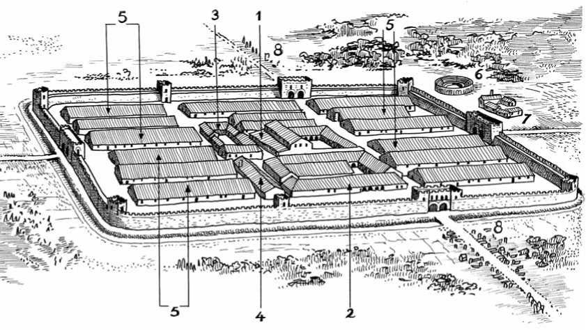
Roman legionary fortress. 1: Principia; 2: Praetorium; 3: Valetudinarium; 4: Horrea; 5: Barracks; 6: Amphitheater; 7: Bathhouse; 8: Cemetery.
Detachments would have undoubtedly been transferred all over the empire. The political turmoil and revolts that happened in the late third century would finally see an end to Isca, somewhere between a. d. 287 and 296.
Auxiliary Forts
As time went by the Roman occupation army in Britain featured fewer and fewer genuine Italian legionaries and more and moreperegrini (non-Roman citizens), e. g., locally recruited auxiliaries and hired foreign mercenaries. Auxiliaries included infantrymen, archers and light cavalrymen from all parts of the empire. After 25 years of service, they would become Roman citizens upon discharge. By contrast, legionaries were citizens upon enlistment. The places housing these units, called auxiliary forts, were much smaller than the legionary fortresses, being on average 5 acres in area as opposed to the fortress’s 50 acres. On the other hand they were much more numerous, over 200 being recorded in Britain. The auxiliary forces were composed of both cavalry and infantry, so their forts included accommodation for horses and varied in size. A fort 400 by 400 feet could accommodate an infantry cohort of about 480 men, a fort 600 by 400 feet could house an ala (plural alae) including 480 cavalrymen and their mounts. Although there were variations on the standard basic theme, the general layout, plan and structure of the auxiliary forts displayed a scaled-down variant of the legionary fortress with the same playing-card plan, the same arrangement of gates, internal streets, and the same location for the headquarters, commander’s house, barracks, stables, workshops, and supply stores.
For example, the auxiliary camp of Gelligaer (Mid-Glamorgan, Wales), built in A. D. 13-12 and intended for 480 men, was 400 by 400 feet. Its enclosure was made of a mass of clay held by inner and outer revetments with an overall width of 20 feet. It included a ditch 20 feet wide and 7 feet deep, four double gateways set between twin towers, and twelve wall - and cornertowers.
The auxiliary camp of Balmuidy (Strathclyde) was one of the two stone-built forts on the Antonine Wall (see below). Its enclosure (460 by 413 feet) was a stone wall 7 feet thick at the base, strengthened by an earth rampart 20 feet wide, with three ditches facing the enemy. Its interior space included the usual standard buildings: headquarters, barracks, and supply stores. Rather roomy for a single cohort, it might have accommodated a garrison of 800 men.
|
9 ___i |
1 |
9 | ||
|
9 |
1 |
9 | ||
|
8 |
8 |
The auxiliary fort of Housesteads in the Hadrian’s Wall was long and narrow (610 by 367 feet) and could accommodate some 800 infantrymen. The fort did not feature a ditch since it stood above a steep natural slope. Its enclosure, which formed a part of the Hadrian’s Wall, was made of a stone wall 5 feet thick backed by a clay rampart 15 feet wide. The fort obviously contained the usual standard buildings: barracks, supply store and so forth. Other auxiliary forts like Fendoch (Tayside, built in A. D. 78-84), Chesters,
Gwynedd, Caerhun, Caernarvon, and Pen Llystyn, for example, conformed to standard unit sizes with slight variations here and there.

This auxiliary fort, based on Chesters, included the following standard elements. 1: Porta Prae-toria (or North Gate); 2: Porta Principalis Sinistra (or West Gate); 3: Porta Decumana (or South Gate); 4: Porta Principalis Dextra (or East Gate); 5: Prin-cipia (headquarters, religious and administrative buildings); 6: Praetorium (commander’s residence); 7: Horrea (supply stores); 8: Fabricae and stabuli (workshops and stables); 9: Barracks.
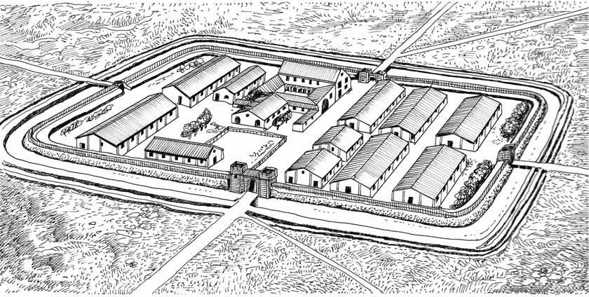
Roman fort
No civil community was allowed within a Roman military camp or fort, but civilians settled outside the walls. Indeed a fort often had an associated civilian settlement outside, forming the nucleus of a township, called a vicus. Roman soldiers were one of the groups in society that had a regular wage and, as has often been the case throughout history, these men with money to spend attracted a range of people providing different civilian services who settled nearby and took advantage of soldiers’ requirements. These commodities included inns, taverns, gambling dens and brothels, and eventually craftsmen, merchants, and traders. So around a fort could develop a settlement, which could easily become a village and possibly a town.
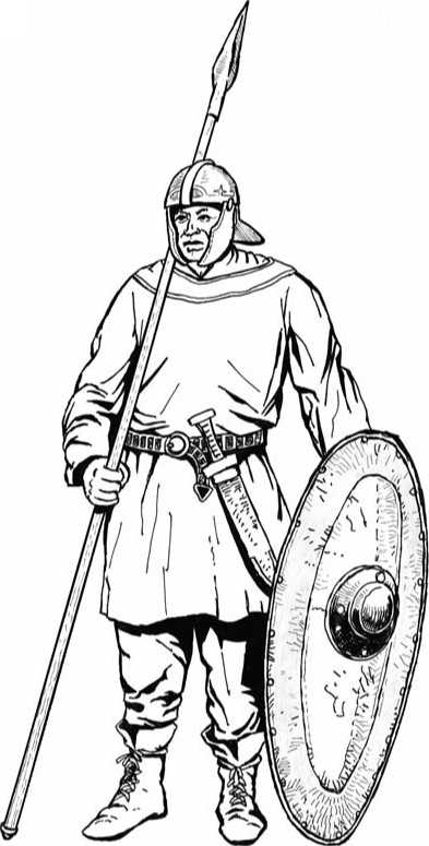
Frankish auxiliary in Roman service. The depicted auxiliary wears a Roman helmet but no body armor. He is armed with a spear, a short sword and an oval wooden shield.
Fortlets and Watchtowers
Small standard units known as fortlets existed. Generally less than a quarter of an acre in area, they included only one or two small barrack blocks for the accommodation of a centuria (80 men), or even a smaller garrison. Fortlets were placed along a road or a river crossing, could be incorporated into border fortifications (e. g., Gask Ridge, Hadrian’s Wall) and were often called milecastles because they were spaced at intervals of one Roman mile (1.48 km or 1,618 yards). Fortlets could also be used as signal stations or beacons along the east coast as occurred during the fourth century. In that case they included a signal tower possibly 100 feet high and 50 feet square. An example of such a signal station has been found at Goldsborough in Yorkshire. Dated from the late 4th century, it was part of a group that included similar works at Filey, Ravenscar, Scarborough and Huntcliffe.
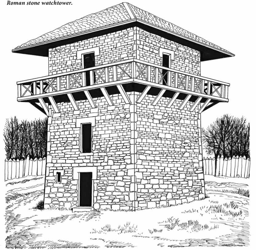
Isolated watchtowers also existed. They were made of timber or stone, very often square in plan, two or three stories high, often with an observation balcony, and set within a low earth wall topped with a palisade or a wattlework parapet and hemmed with a ditch. They could accommodate only an outposted contubernia (eight men, the smallest unit of the Roman army), and were spaced out along a coastline, a road or river or along a border to observe traffic and population movement. The first floor of the tower was used as a storage space for food and equipment. Off-duty members of the guard detachment slept and cooked on the second floor, while their
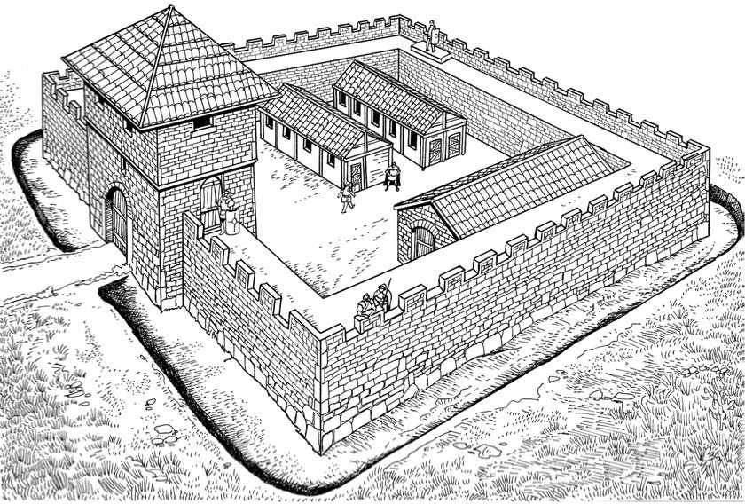
Roman fortlet.
Comrades observed the area around them from the third-story guardroom or the balcony all around it. When built in a line at a border like the Gask Ridge, for example, watchtowers were within sight of each other, but not always within actual supporting distance. Fortlets and watchtowers had a twofold role: to see and be seen. They were, in modern parlance checkpoints fulfilling a control, observation, and also deterrent function, as they were physical reminders of Rome’s omnipresent power.
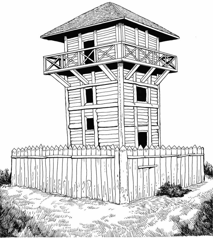
Roman timber watchtower. Isolated watchtowers were often protected by a V-shaped ditch and a palisade.
Frontier Works
As the first century matured, the frontiers of the Roman Empire became increasingly fixed, and what were once temporary limits became definitive borders. As a result, the function of the legions was no longer conquest but policing the border tribes, mounting punitive raids, and preventing tax evasion and livestock rustling. For this purpose the Romans established frontier defensive works known as limes (plural limites). The first limes was established in Germany, along the rivers Rhine and Danube, under the reign of the Emperor Dominien (81-96). The defensive program was continued by Trajan (97-117), Hadrien (117-138) and many of their successors. The frontiers of the Roman Empire were largely based on natural features (e. g., rivers, mountains, deserts, forested areas), which were reinforced with artificial defenses. In what later would become England, the Romans made a section of limes fortification, known as the Gask Frontier. This artificial border placed under
Permanent military surveillance included forts, fortlets and watchtowers linked by a military road. This was built between a. d. 80 and 90, thus about 40 years before the famous Hadrian’s Wall. The Gask line started at Glenbank just to the north of Dunblane and reached to Bertha, just upstream of Perth on the Tay. It ran for most of its length along the prominent 70 m high east-west oriented Gask Ridge (hence its name) on the northern side of Strathearn in Perthshire, between the Highland massif and the peninsula of Fife.
The most striking remnant of the Roman presence in Britain is without doubt the fortified frontier line known as Hadrian’s Wall, built, as the name implies, by order of Emperor Hadrian. South and central Britain were parts of the empire, but in northern Caledonia (Scotland) the Romans made no headway. On the edge of rough heather moorlands lived the half-savage tribe of the Brigantes, and still farther north the fearsome Picts, both equally refractory to any peaceful penetration. After disappointing and disastrous attempts, the Romans abandoned the idea of subduing the north, and instead fortified the frontier in order to hold them back, hereby showing that they no longer had the offensive initiative. Hadrian’s Wall was intended to clearly and physically mark the border of the empire, impose Roman order, repulse Scottish raiders, improve economic stability and provide peaceful conditions in the frontier zone.
The defensive system was an extraordinary feat of engineering. It had a length of 73.5 miles (117 km), and stretched across the width of northern England between the mouth of River Tyne and Newcastle-upon-Tyne in the east to Carlisle, Bowness and the shore of the Solway Firth in the west. Construction started in A. D. 122 and six years later was largely completed. Hadrian’s Wall consisted of a continuous stone or turf wall. At intervals of one Roman mile (1.48 km or 1,618 yards) there was a small fort (called a milecastle) abutting the rear of the wall, and between two milecastles, there were two watchtowers built at intervals of 540 yards. In front of the wall was a V-shape ditch and a glacis, except where the ground was very steep. The garrison to man this defensive system totaled some 10,000 men, who were housed in a series of auxiliary forts like the previously discussed Vercovicum (Housesteads) and Cil-urnum (Chesters). Forts, fortlets, and towers were linked by a military road that ran parallel to the wall. The garrison of Hadrian’s Wall suffered serious attacks, notably in A. D. 180, and also in A. D. 196 and 197, which were followed by long periods of calm. However, Hadrian’s Wall would be misunderstood if it were regarded as a kind of Maginot Line protecting a peaceful province. It was rather a means of separating the friendly tribes in the south from northerners hostile to Rome as diplomacy also played its part. The wall remained occupied by Roman troops until their withdrawal from Britain in the late fourth century, when barbarian invasions, economic decline, and military coups loosened the empire’s hold on Britain. By a. d. 410, the Roman administration and its legions were gone.
Hadrian’s Wall was the first of two fortification lines built across Great Britain, the second being the Antonine Wall in what is now southern Scotland. Pressure from the Caledonians may have led the Roman Emperor Antoninus Pius (reign 138-161)
To send the empire’s troops farther north. The Antonine Wall was a stone and turf fortification built across the Central Belt of Scotland, between the Firth of Forth and the Firth of Clyde, bringing Lowland Scotland within the Roman province of Britannia. The northernmost frontier barrier of the Roman Empire, it ran approximately 63 km (39 miles), was about ten feet high and fifteen feet wide, and was fronted by a deep ditch on the north side. Construction began in A. D. 142, and took about twelve years to complete. The wall was protected by sixteen forts, with a number of small fortlets and watchtowers between them. Troop movement was facilitated by a road linking all the sites known as the Military Way. Despite this auspicious start the wall was abandoned around a. d. 163 after only twenty years, and the garrisons relocated back down south to Hadrian’s Wall. In 208 Emperor Septimius Severus re-established legions at the wall and ordered repairs, and this has led to the wall being referred to as the Severan Wall. However, the occupation ended only a few years later, and the wall was never manned and fortified again. The highland vastness of Scotland remained a free refuge for the Celtic people of Britain. Most of the turf-built Anto-nine Wall and its associated fortifications have been destroyed over time, but some remains are still visible today, although they are much less evident than the better known Hadrian’s Wall to the south.
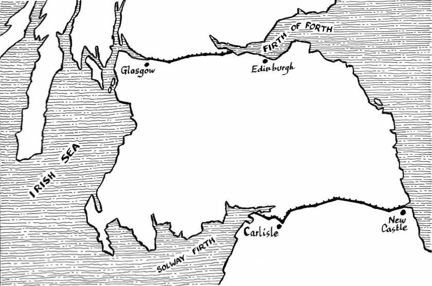
Hadrian’s Wall. The map shows Antonine’s Wall (top) and Hadrian’s Wall (bottom).
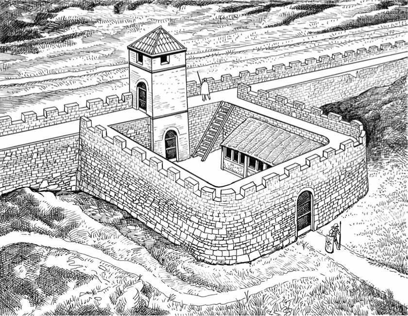
Milecastle in Hadrian’s Wall. Spaced at intervals of one Roman mile regardless of natural conditions, each milecastle included a crenallated enceinte with watchtower, a lavatrina (latrine), and a barrack block divided into one dormitory for 16 men and a supply and equipment store.
Saxon Shore Forts
The so-called Forts of the Saxon Shore (Litus Saxonicum in Latin) were a girdle of fortified ports built by the Romans along the southern coast of Britain from the actual county of Norfolk to Hampshire. There were originally at least ten of them, possibly eleven, of which nine survive in varying states of preservation. Most were built towards the end of the 3rd century A. D., though some (e. g., Richborough and Reculver) incorporated parts of earlier fortified buildings. In the 3rd and 4th century a threat appeared in the form of Germanic raiding along the vulnerable and hitherto undefended south and east coasts. The origin and purpose of the Litus Sax-onicum were to dispose of powerful military and naval installations in order to protect trade and communication between Gaul (France) and Britannia, to keep watch against Saxon raiders (from northern Germany) and Frisian pirates (from the present day Netherlands), to drive them away if they landed, and to pursue them when they had attacked and looted a Romano-British settlement on the coast. There was thus a provincial naval force called Classis Britannica (Britain Fleet), whose primary
Task was the secure ferrying of goods, supplies and troops, and the guarding of the commercial shipping lanes between Gaul and Britannia. As is often the case in coastal defense, the forts also played a deterrent role, as the fact that well-trained forces were at constant readiness was often sufficient to deter raiders and pirates. The Roman fleet included two sorts of ships: the military oared galley and the merchant sailing vessel. The nine preserved Saxon fortified ports are: Branodunum (modern day Bran-scaster); Gariannonum (Burgh Castle); Othona (Bradwell); Regulbium (Reculver); Rutupiae (Richborough); Dubris (Dover); Lemanis (Lympne); Anderida (Pevensey); and Portus Adurni (Portchester). The Litus Saxonicum, placed under command of a naval officer who bore the resounding title Comes litoris Saxonici per Britannia (Count of the Saxon shore of Britain), formed a defensive system. Although there were considerable variations within the group of Saxon Shore forts, they all had certain similar characteristics. They were all on or near the sea, placed at strategic points—harbors or river-mouths—guarding the natural waterways which seaborne raiders or invaders of southeastern Britain might attempt to force. Each fort held harbor installations from which a Roman fleet could operate, and a substantial garrison including naval personnel (officers, sailors and oarsmen), marines (who were employed in amphibious operations against pirate ships and bases), and cavalrymen (who would fight raiders ashore). In other words, the Saxon shore forts were intended to keep what would become the English people out of what would become England. No doubt that these combatants included large numbers of non-Roman auxiliaries, hired local men, and mercenaries. Few of the Saxon shore forts were on or near important Roman roads, so communication between them must have been by sea. The general structure was basically similar to other forts, and the plan used was the rectangular playing-card enceinte, except Pevensey, which has an irregular oval layout fitting the natural configuration of the site. The main variations were in size. The Saxon forts, noticeably larger than the auxiliary forts, had an average size of about 7 acres. They had thick walls (up to 14 feet), which were not always backed by an earth rampart, that is they were free-standing walls made of stone in the manner and dimensions of later medieval castles. The walls’ height varied. For example, Pevensey’s walls were 28 feet high, Richborough 25 feet, and Lympne 23 feet. In many cases entrances consisted of twin-towered gates, fairly regular in type. Walls included projecting D - or U-shaped towers flanking wide ditches. Towers were usually roofed and adapted to the mounting of light artillery machines like the ballista and the scorpion. Very little is known about the buildings inside the forts but they were likely to have had standard accommodation for a strong garrison and naval personnel, as well as workshops for shipwrights and granaries and stores in addition to the usual headquarters and commander’s quarters as described above.
There were also fortified harbors on the other side of the Channel in Gaul, including Mardyk near Calais, Boulogne, Rouen (inlands on the River Seine), Bayeux, Coutances and Avranches (in what later would become Normandy), Saint-Servan near Saint-Malo, Carhaix and Brest (in Armorica, present day French Britanny). Whether these ports were part of the Litus Saxonicum remains unclear, as they guarded places well worth defending in themselves, but they did not seem to have been designed to prevent seaborne invaders from penetrating into the hinterland. Obviously the Saxon shore forts failed to fulfill the task for which they had been established. They were indeed invulnerable when garrisoned at the planned level, but by the beginning of the 5th century the Roman Empire, weakened by internal power struggles and threatened at its very heart, could no longer spare soldiers to defend the remote northern island. When the troops, who had defended Britain for some four hundred years, sailed from the Channel ports, never to return, the system became unworkable. Pevensey, for example, was taken by assault in 491, something which had never happened under the Romans. Other forts fell to the Germanic invaders without a fight.
Most of the Saxon shore forts slowly rotted away. First to go were the timber and fittings, then the roofs, until at last only the massive stone walls, rubble and iron-hard cement remained to defy 2,000 years of British weather. The Saxon shore forts of Pevensey, Dover and Portchester were later reused and adapted by the Norman and Plantagenet kings, and the Roman enclosures were used as baileys to subsequently-built medieval castles.
(Continued on page 89.)
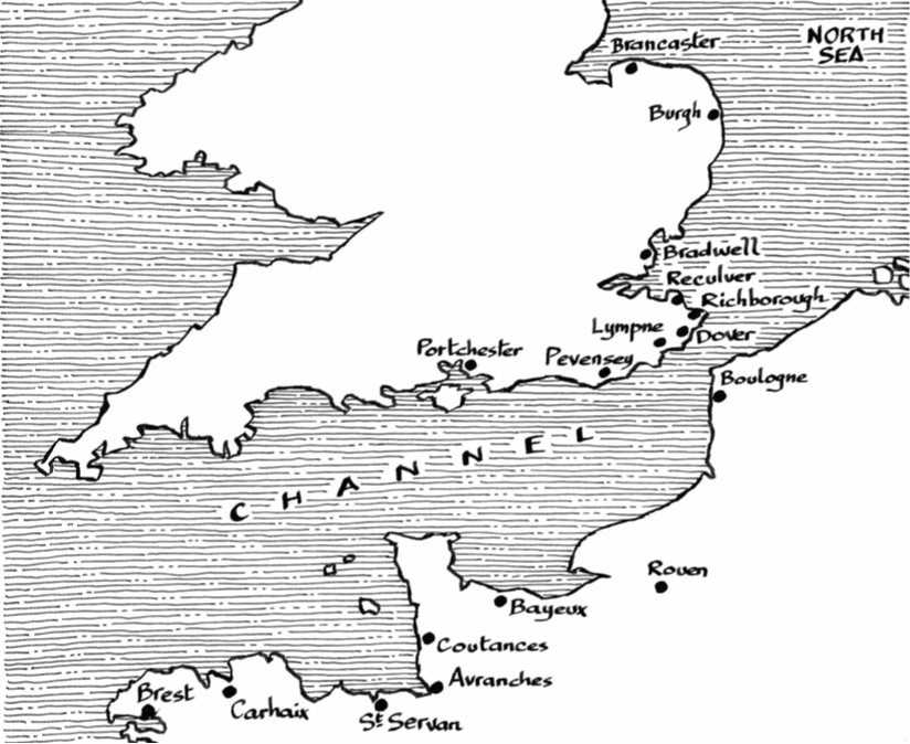
The map shows the Saxon shore forts in southern England and the main sea harbors in Gaul.

Richborough (Rutupiae) can claim to be, with Hadrian’s Wall, the most important Roman fortification in Britain in regard to its preservation, archaeological finds and historical interest. The Roman invasion of Britain in a. d. 43 was led by Senator Autus Plautius, with an army of some 50,000 men. Archaeological evidence suggests that Richborough was the bridgehead for this invasion. As the conquest of Britain rapidly advanced Richborough soon became an important naval supply base, as evidenced by the laying of new roads, and the erection of several timber buildings believed to be storehouses. By a. d. 85 the site underwent a substantial change. The central timber buildings were demolished, and a monumental four-way arch was constructed, the walkways beneath which formed the shape of a large cross that can still be clearly seen today. As Richborough’s status grew, so did the settlement around it. However, towards the middle of the 3rd century, military considerations had again come to the fore. A large percentage of the central buildings were demolished and the central monument was ringed with a series of triple ditches, suggesting that this had become a useful lookout tower. These excavated triple ditches are still a striking feature of the site today. By the end of the 3rd century the earth fortifications were dismantled and the ditches backfilled to prepare for the construction of a much more substantial fortification enclosed by a stone perimeter. These massive walls with their corner towers, which were up to 11 feet (3.5 m) thick in places, surrounded by a double ditch, are the most impressive part of the ruins as seen today. Little is known of the internal buildings, as these were most likely constructed of timber. The changes are believed to have been completed by a. d. 286. By the end of the 4th century Richborough Roman fort had ceased to be garrisoned by regular Roman troops, but the site retained its status until approximately a. d. 402. The map shows the following. 1: Archway; 2: Second-century ruined houses; 3: Third-century earth fort; 4: Late 3rd century stone enclosure with towers; 5: North postern; 6: West gate; 7: Parts of the fort that have collapsed and disappeared; 8: Present railway track.
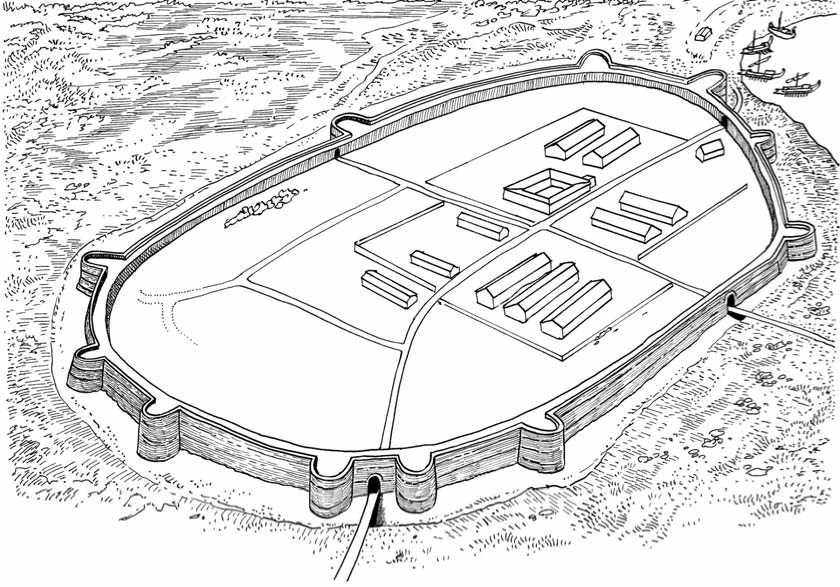

Top: Roman Pevensey. A part of the Saxon shore forts, Pevensey, then named Anderida, was egg-shaped in plan and quite untypical of Roman fortification, in which the rectangle was the usual pattern. The site was well-chosen, approachable by land only from the southwest. There was an east gate, which led to the harbor where a squadron of galleys or other scouting boats was stationed. The enclosed area is about 8 acres with walls 25 feet high and 12 feet thick; the rubble core was faced with green sandstone and iron-stone. Anderida was probably connected with its neighboring Saxon forts by a series of signal towers. The sea has long since receded from Pevensey but up to the early Middle Ages it could be reckoned as a port. The interior of the Roman fort was filled with rows of barracks, a supply store, and administrative buildings, all presumably of timber construction since no trace of stone foundations has been found. The fort was later reused by the Normans.
Left: Tower at Pevensey (reconstruction).
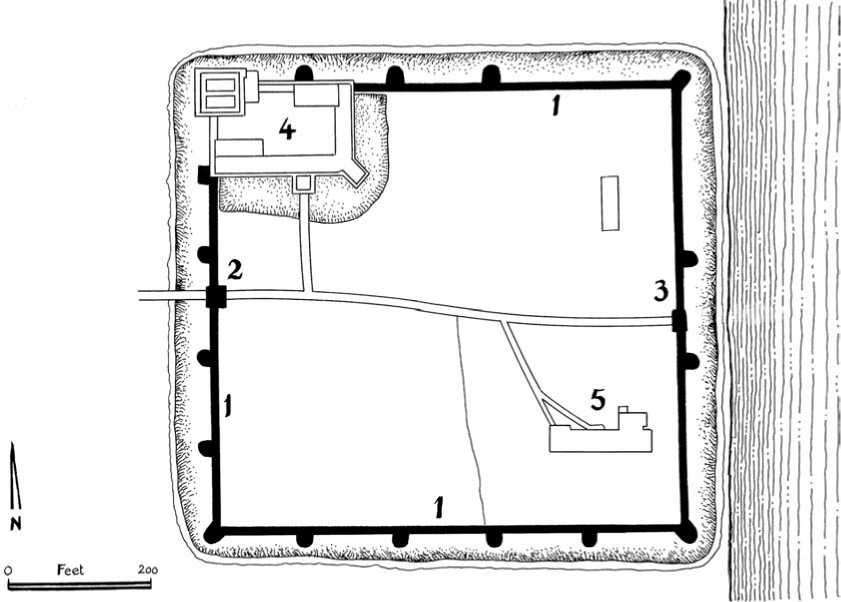
The most impressive and best-preserved of the Roman Saxon shore forts, Portchester Castle (Hampshire) was originally built in the late 3rd century. It forms a vast square, some 200 yards each way, covering 10 acres. Midway in the east and west sides are gateways, in each of the north and south sides is a postern, and the whole enclosure was reinforced by 20 towers, of which 14 are preserved. Portchester is the only Roman stronghold in northern Europe whose walls still mainly stand to their full 6 m height, complete with most of their original towers. Subsequently housing an Anglo-Saxon settlement after the departure of the Romans, the huge waterside fortress became a Norman castle in the 12th century, when a formidable tower-keep was built in the northwest corner. 1: Roman stone wall with towers and ditch; 2: West gate; 3: East gate; 4: Norman castle with keep; 5: Medieval Norman church.
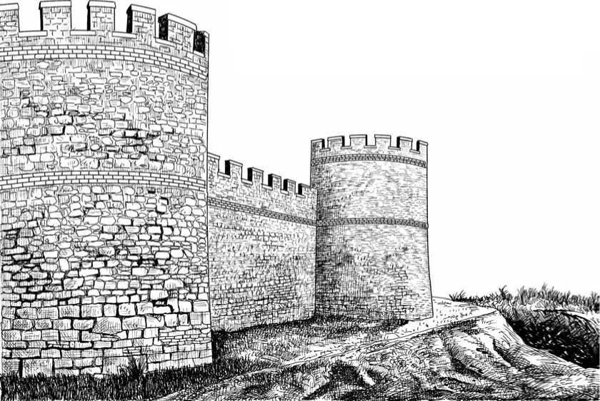
Portchester towers and walls (reconstruction). The masonry consisted of a concrete core, faced with flints, with frequent bonding courses of red brick and stone.
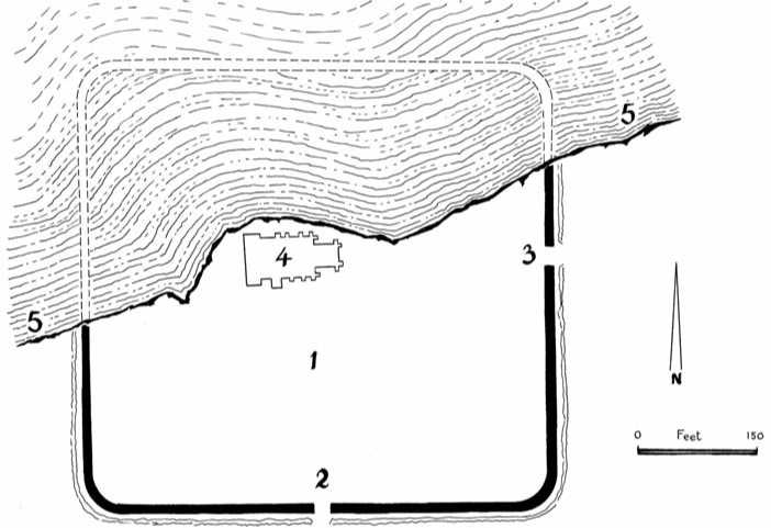
Built between a. d. 180 and 185 as Regulbium, Reculver was one of the Saxon shore forts. It was a location for a fort with lighthouse and watchtower, presumably because of its strategic position at the northern entrance to the important Wantsum Channel, and covered the mouths of both the River Thames and the River Medway. Owing to coastal erosion, half the fort has now disappeared into the sea and the later-built Saxon church ruins are now on the edge of a steep cliff. 1: Site of 3rd-century headquarters building; 2: South gate; 3: East gate; 4: Saxon church built c. A. D. 669; 5: Present coastline.


 World History


