The Great Basin occupies about 165 000 square miles of the intermontane West, encompassing most of the state of Nevada, as well as parts of California, southern Oregon, western Utah, and small portions of Idaho and Wyoming (Figure 1). As its name implies, it has no outlet to the sea, with its rivers and streams generally emptying into low desert lakes and playas, such as the Carson Sink and Great Salt Lake Desert, or simply disappearing through evaporation or absorption into the ground. In addition to its desert valleys, much of the Great Basin is rippled with a series of massive northwest-southeast-trending mountain ranges, many with peaks in excess of 10000 ft. The abrupt shifts in elevation, and their corresponding rainfall and temperature regimes, produce a spectacular range of plant communities and habitats, with vast expanses of sagebrush and shadscale in lower valleys, stands of pinyon and juniper at mid-elevations, and pockets of conifer forests on the highest peaks.
The Great Basin is the home of the ethnographic Paiute and Western Shoshone, whose simple but exquisitely adapted desert lifeways loom large in the development of American anthropology. The Great
Basin provided the theoretical backdrop for Julian Steward’s pioneering work on cultural ecology, as well as his conception of the family band. This extraordinary landscape, and the people who have inhabited it over the last 13 000 years, continue to provide a laboratory for the study of human adaptation and the environment, and more specifically for the relationship between simple hunter-gatherer societies and the deserts they inhabit.
The natural and cultural histories of the Great Basin, however, have been far from static. Major shifts in Late Pleistocene and Holocene climate regimes, with their concomitant effects on environmental productivity, have long been recognized. At the close of the last Ice Age, for instance, immense lakes such as Lahontan and Bonneville covered vast tracts of the Great Basin (Figure 2). These lakes shrank and in some cases completely evaporated, as warmer and dryer conditions set in during the Early Holocene. The Middle Holocene, dating to about 8000-4000 years ago, was marked by even more severe droughts that altered major hydrological and ecological systems, fundamentally shifting the course of landscape evolution. By the Late Holocene, with shorter but often still extreme droughts, climatic conditions were greatly improved. Through all of this, human beings have attempted to wrest a living from this landscape, changing and adapting to this challenging desert realm.
The following presentation tracks the chronological progression of prehistoric lifeways in the Great Basin within this dynamic natural context. We emphasize general themes and patterns, at the expense of more detailed local examples and explanations.
Chronology
While archaeologists have proposed several regional chronological sequences and schemes, we divide time into five broad periods (cal BP = calendar years before present):
1. Palaeo-Indian 13 500-8000 cal BP,
2. Early Archaic 8000-4000 cal BP,
3. Late Archaic 4000-1400 cal BP,
4. Formative (Fremont) 1400-600 cal BP,
5. Recent Prehistoric Post-600 cal BP.
The Palaeo-Indian period (13 500-8000 cal BP) While there have been occasional claims of a more ancient Pleistocene occupation, most archaeologists now agree that the earliest definitive human use of the Great Basin is reflected by the fluted projectile points recognized across the New World as ‘Clovis’ points (Figure 3), named for the place in New Mexico where they were first found. These artifacts have been recovered almost exclusively from the surfaces of

Figure 1 Map of the Great Basin. By Tammara Ekness Norton.
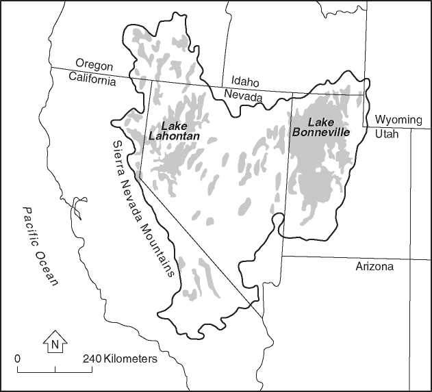
Figure 2 Location of Lakes Lahontan and Bonneville. By Tammara Ekness Norton.
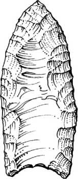
Figure 3 Clovis point. By Tammara Ekness Norton.
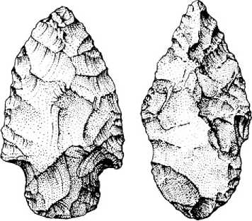
Figure 4 Stemmed points. By Tammara Ekness Norton.
Ancient landforms, such as playa margins, rather than from intact buried deposits. Thus they have not been found in the Great Basin in contexts suitable for radiocarbon dating and cannot be directly dated; instead they are assumed to date in the range of Clovis points found elsewhere in North America, that is, between 13 500 and 11 500 years old.
In western North America, Clovis points have been found in association with the bones of now-extinct megafauna (e. g., mammoth and large bison), suggesting that these early populations were focused on big-game hunting. This also may have been the case in the Great Basin, but it has not yet been demonstrated. Great Basin Clovis peoples are thought to have been highly mobile, traveling in small groups and settling around lakes and along rivers where game also tended to congregate. Millingstones, the hallmark of Archaic and other, later-dating prehistoric occupations, are generally absent from Clovis sites.
Prehistoric occupation of the Great Basin toward the latter end of the Palaeo-Indian Period (between 11500 and 8000 cal BP) is documented by various large lanceolate and stemmed projectile points (Figure 4) which typically occur with a variety of heavy coretools, cores, stone knives, domed scraping tools, and chipped-stone crescents. Often referred to as the Western Pluvial Lakes tradition, and like the Clovis pattern that preceded it, archaeological assemblages dating to this time generally occur around the former shores of now-extinct pluvial lakes and other ancient landforms. Evidence of this later pattern, however, is found throughout the Great Basin, suggesting larger populations. While archaeologists have tended to view Western Pluvial Lakes peoples mostly as big-game hunters, many sites from this period have a wide variety of artifacts that reflect both hunting (projectile points, flaked stone cutting implements) and plant-food processing (grinding slabs, handstones). These tools have been found with significant concentrations of small game, fish, and shellfish remains, clearly reflecting a wider subsistence focus than just the hunting of large game.
There is no question, however, that Western Pluvial Lakes populations wandered far and wide in pursuit of the plant and animal resources they so depended on. Evidence for this is provided in the obsidian source profiles of projectile points and other tools dating to this time. Obsidian is a volcanic glass that was preferred by prehistoric stone workers for making their tools. Each obsidian flow exhibits its own distinct chemical signature, which can be identified using techniques known as X-ray fluorescence (XRF) mass spectrometry or instrumental neutron activation analysis (INAA). By matching the proportions of trace elements in an obsidian artifact with those from a known volcanic glass flow, archaeologists can determine the quarry where the material was obtained, and how far the toolmaker carried it before eventually discarding it. This information is then used to reconstruct broader settlement patterns, on the assumption that the distribution of the discarded obsidian reflects the travel patterns of the particular group of people who discarded it. Archaeological sites of the Western Pluvial Lakes Tradition usually contain a wide variety of obsidians from different, far-flung source locations. This pattern, which has been seen throughout the Great Basin, is interpreted as evidence of a population’s high mobility and large geographic range.
Although no one knows the origin of these earliest inhabitants of the basin, recent discoveries of human skeletal remains and re-analyses of older museum collections have shed new light on this old question. Radiocarbon dating of human remains and associated artifacts found in the Carson Sink area during the 1940s showed them to be in excess of 9000 years old. One of these burials, recovered from Spirit Cave (Figure 5), represents one of the oldest and

Figure 5 Location of Spirit Cave. By Tammara Ekness Norton.
Best-preserved sets of human remains ever recovered in North America. What is even more noteworthy, however, is that these skeletal remains, as well as some found elsewhere in North America, are morphologically different from those of the ancestors of modern Native Americans. These findings probably indicate that there were multiple migrations of different groups from northeast Asia into North America and eventually into the Great Basin. This line of scientific inquiry is somewhat controversial, because many contemporary Native American tribes who call the Great Basin home believe that their direct ancestors were the original inhabitants of these lands, and that their people were created here.
The Early Archaic (8000-4000 cal BP) As we have noted, there is compelling palaeoenvironmental evidence indicating that the transition into the Early Archaic (Middle Holocene) period was marked by a shift to both warmer and dryer climates in the Great Basin. A number of archaeologists have speculated that this Middle Holocene warm period may have either reduced human populations or led them to totally abandon the central Great Basin during this interval. As evidence, they point to a series of caves and rock shelters in the region that have human occupation sequences at least 9000 years long, but show evidence of abandonment during parts of the Middle Holocene warm period. This drought may have been more severe, and its effects on human populations more extreme, at the early end of this period (c. 8000-5500 cal BP), but it is likely that dry conditions prevailed until about 4000 cal BP. In this scenario, better-watered areas along the western, northern, and eastern portions of the Great Basin may have sustained occupation during this time or even acted as refuges for populations who were forced to abandon the central Basin. Other archaeologists, while acknowledging that this was a time of severe environmental stress and declining populations, argue that large tracts of the Great Basin were never completely abandoned.
Early Archaic artifact assemblages, and the life-ways they represent, show more regional variation than their Palaeo-Indian counterparts. In the southwestern Great Basin, many of the sites dating to this time are characterized by Pinto-series projectile points (Figure 6) and increasing numbers of milling tools, but retain many of the large, percussion-shaped cores, knives, and scraping tools characteristic of the earlier Western Pluvial Lakes tradition. It follows that lifeways associated with these two assemblage types - those of small, mobile bands with geographically extensive foraging ranges - were also little changed. Along the northern tier of the Great Basin, however, a completely different pattern emerged at this time, marked by the presence of Northern Side-notched dart points (Figure 7). As nearly as can be reconstructed, these points are distributed in a
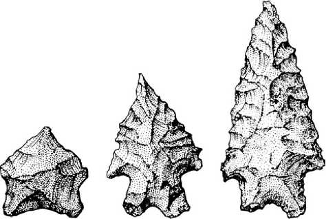
Figure 6 Pinto Series points. By Tammara Ekness Norton.
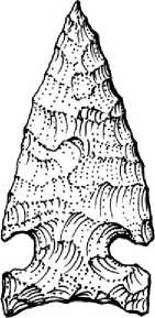
Figure 7
Norton.
Northern Side-notched Point. By Tammara Ekness
Fan-like pattern across the Columbia Plateau and the northern Great Basin, suggesting cultural influences from the north during this period.
The best known of these site complexes is located in Surprise Valley, California, in the northwestern part of the basin (Figure 8). They contain formal, semi-subterranean house structures which date to between 6500 and 4500 years ago. Stylistically, distinctive artifacts found in these deposits include large side-notched projectile points, antler wedges, mortars with ‘V’-shaped bowls and pointed pestles, ‘T’-shaped drills, tanged blades, and flaked stone pendants. All of these artifacts and features appear to be of northern derivation, with comparable forms identified at numerous sites on the Columbia Plateau.
The Late Archaic (4000-1400 cal BP) A maj or
Restructuring of the subsistence-settlement strategies used by Great Basin peoples occurred during the Late Archaic period. The small, highly mobile groups that characterized much of the Early Archaic were replaced by larger aggregations of people living in more permanent settlements. These settlements result in an archaeological record characterized by large accumulations of midden (organic-rich sediments Created by human occupation) and artifacts, as well as elaborate house structures and storage facilities. This higher degree of sedentism was probably supported by a more intensive collection and storage of plant foods, which is evidenced in the archaeological record by an increased frequency of milling equipment and the recovery of a wide range of wild seeds.
A good example of a Late Archaic village was discovered in Owens Valley, within the southwestern portion of the Great Basin. Excavations at CA-INY-30 (Figure 9) revealed the presence of house structures made from frames of wooden poles covered with thatched roofs made from tule reeds. The houses contained a rich assortment of tools, including caches of obsidian knives, projectile points, and bone awls. Several storage pits were also found, one with a large accumulation of pinyon nuts. Midden deposits adjacent to the houses produced food remains indicating a multiseason occupation. Fall was marked by pinyon nuts, winter by migratory water fowl, while spring and summer were indicated by a variety of small-seeded plants like Indian rice grass.
This new village-based pattern was accompanied by the emergence of several other settlement types, including specialized hunting camps. Excavations at these sites indicate that large-game hunting became more important than at any other time in Great Basin prehistory, and much of this hunting was focused on bighorn sheep killed high in the mountains. One of the best examples of this comes from the White Mountains, where projectile points, knives, and butchered sheep bones were discovered at sites located more than 10 000 ft above sea level. These remote habitats had rarely been used until the Late Archaic, when small groups of hunters armed with atlatls and darts tipped with Elko points (Figure 10) began killing sheep among the craggy alpine peaks, and transporting the meat down to the lowland villages.
The focus on large-game hunting expanded well beyond the simple goal of providing food for people living in the lowland villages. Archaeologists interpret this from the explosion of ritualistic behaviors associated with hunting that emerged during this period. Perhaps the most obvious example of this behavior can be seen in the increased production of petroglyphs (artistic images pecked into natural rock outcrops), most of which portray bighorn sheep, often associated with human hunters (Figure 11). Sheep petroglyphs are found throughout the Great Basin, but the highest concentrations are located in the volcanic Coso Mountains of southeastern California, where thousands of engravings were created during the Late Archaic period. Other ritual activities were indicated by the severed heads of mountain sheep cached in remote mountain caves, and the
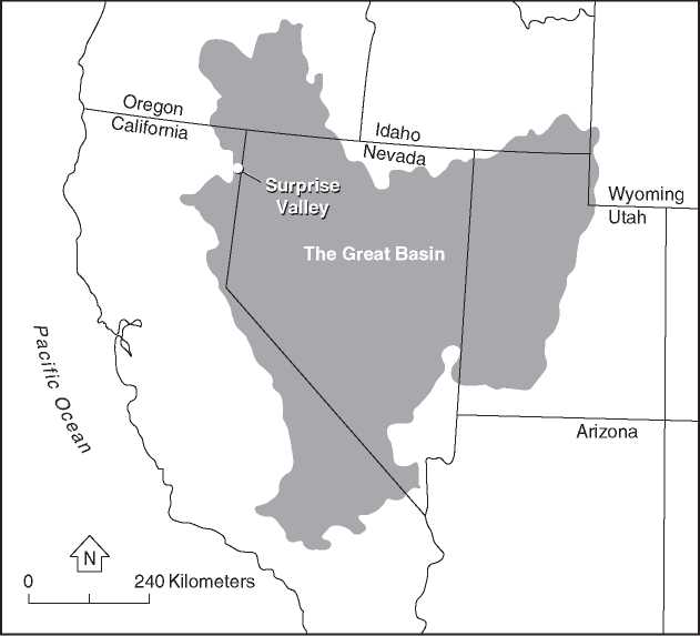
Figure 8 Location of Surprise Valley. By Tammara Ekness Norton.
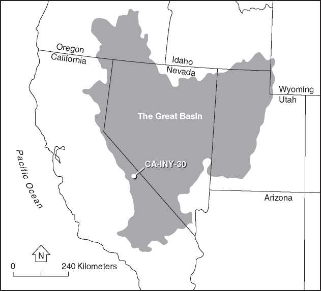
Figure 9 Location of CA-INY-30. By Tammara Ekness Norton.
Manufacture of split-twig sheep figurines found at many sites in the southernmost reaches of the basin.
This period of cultural elaboration was accompanied by the interregional exchange of many commodities,
The most conspicuous being obsidian. As we have noted, obsidian occurs naturally at a limited number of locations, and these places can be identified with XRF or INAA analysis. Obsidian can also be dated, because when a new surface of the material is exposed to the atmosphere by a stone worker, it begins to absorb small amounts water, forming a hydration rim. The longer an artifact is exposed,
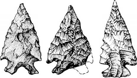
Figure 10 Elko points. By Tammara Ekness Norton.
The thicker the hydration rim becomes. Measuring these hydration rims, and calibrating them against radiocarbon dates on organic remains (e. g., an obsidian artifact found in a burnt house structure), allows archaeologists to estimate how quickly the hydration rim develops on a particular type of obsidian. This in turn allows us to convert a hydration rim reading (measured in microns) to an approximate date range. The data that have already been generated by these techniques show that the Late Archaic stone workers produced thousands of obsidian blanks, which were exported across hundreds of miles to meet the demands of hunters throughout the region. Some of the obsidian artifacts were traded over the Sierra Nevada and across the Central Valley of California, and ultimately reached the Channel Islands off the Santa Barbara coast, more than 50 miles out to sea.
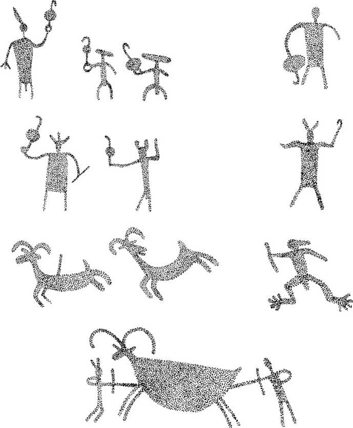
Figure 11 Petroglyphs of hunters and bighorn sheep. By Tammara Ekness Norton.
The Formative Period (1400-600 cal BP) For a brief period between about 1400 and 600 cal BP, a farming culture known to archaeologists as the Fremont, occupied significant portions of the Great Basin (Figure 12). They ultimately settled in much of what is now Utah, and appear to have borrowed many of their farming techniques from neighboring Anasazi populations living in the Southwest. Although some Fremont groups focused on the cultivation of maize, constructed extensive pit-house villages with adobe-walled granaries, and created elaborate forms of pottery and rock art, others lived in smaller settlements and used a mixed economy reliant on both hunting/ gathering and agricultural production.
The first hints of Fremont culture can be found at sites dating between 2500 and 1400 cal BP, which begin to show evidence of a few pit houses with slab-lined pits containing corn, though it was not until after about 1400 cal BP that full-scale village life emerged among these people. A good example of a major Fremont settlement is the Nawthis Village, located in Utah just east of Salina. Many of the houses there were composed of deep, circular pits covered with superstructures of timber and mud (Figure 13). Storage facilities were usually built above ground, and consisted of several rectangular rooms made of adobe and lined with large slabs of stone (Figure 14). Typical Fremont artifacts include the bow and arrow tipped with Rose Spring points (Figure 15); grayware pottery, sometimes painted with geometric designs; rod and bundle basketry; leather moccasins; polished stone balls; and ceramic human figurines. As with Late Archaic peoples, rock art was important to the Fremont. A signature icon of this culture is the engraving of broad-shouldered humans wearing elaborate necklaces, earrings, and headdresses.
Subsistence remains from these sites indicate that maize, beans, and squash were important staples, but were supplemented with wild foods such as pinyon nuts, chenopod seeds, cattails, Indian rice grass, and various types of game. Ditches were sometimes constructed to irrigate crops, beginning at the mouth of a canyon and directed downstream across an alluvial fan and into the cultivated fields. Many of the canyon sites also contain pole and mud-walled granaries built into overhangs and crevices in hard-to-access places. These facilities probably indicate that people living in even the largest villages took to a more mobile hunter-gatherer lifeway from time-to-time, and used these caches to help secure their stored resources while they were away.
The Fremont also occupied much smaller settlements, particularly along the northern and western margins of their territory. These sites often contain two or three houses, representing just a few families, or small deposits in caves and rock shelters created by part-time hunter-gatherers traveling away from their home villages. Why the Fremont chose to farm at

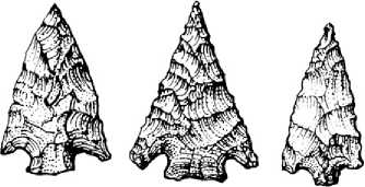
Figure 15 Rose Spring points. By Tammara Ekness Norton.
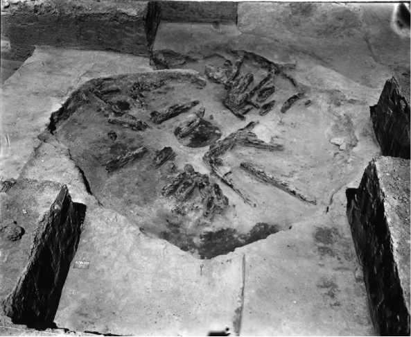
Figure 13 Circular pit from Nawthis Village. From Exploring the Fremont by David B. Madsen.
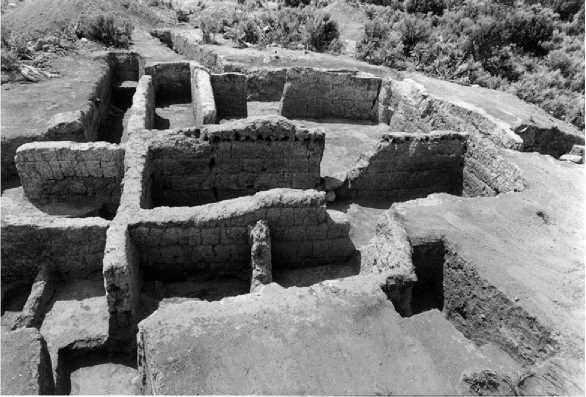
Figure 14 Storage facilities from Nawthis Village. From Exploring the Fremont by David B. Madsen.
Certain times and be hunter-gatherers at others remains an important research issue for Great Basin archaeologists. Most researchers believe that the decision to farm was based largely on the changing availability of the most lucrative wild foods in the
Region, such as pine nuts and mountain sheep. If these resources were readily available, then people would spend little energy farming. But if human populations over-harvested these wild commodities, or their productivity dropped due to climatic changes, then people would focus on the more labor-intensive cultivation of domesticated plants.
Sometime around 600 BP, the Fremont culture disappeared from the archaeological record. No one really knows why this occurred. Many archaeologists think that severe droughts associated with what is known as the Medieval Climatic Anomaly or the Medieval Warm Period (1000-600 cal BP) made it impossible to irrigate crops on a regular basis, and that a new group of
Hunter-gatherers moved in and took over the territory. This new group, which spoke languages belonging to the Numic family (Paiute, Shoshone, Ute), either pushed the Fremont back toward their agricultural neighbors in the Southwest, or assimilated them into the new lifeway through intermarriage. While we cannot be sure which of these actually happened, analysis of ancient DNA from Fremont skeletal materials shows greater affinities with the Anasazi than with the Numic, providing some support for the Fremont being displaced from the Great Basin.
The Recent Prehistoric Period (post-600 cal BP)
The Recent Prehistoric period was marked by major shifts in land use resulting from the rapid spread of Numic populations across the region. Linguistic data indicate that Numic speakers originated in the southwestern corner of the Great Basin and spread quite quickly. By the time non-native people entered the region, much of it was occupied by people speaking similar (Numic) languages. If these people had lived here for a very long time, their languages would have diverged - in the way that Latin, which spread over much of Europe during the Roman Empire, evolved in different areas into French, Spanish, Italian, Portuguese, and Romanian. That a Northern Paiute person living just east of Yosemite could speak to someone living on the Snake River indicates a relatively recent spread of a single population, perhaps occurring during the last 500 years or so.
Unlike the large, centralized villages that characterized much of the Fremont and Late Archaic cultures, Numic peoples used smaller settlements inhabited by one or a few independent households on a seasonal basis, and are marked by brownware pottery and new projectile point types (desert side-notched/ cottonwood triangular points; Figure 16). Increased amounts of milling gear and specialized basketry, including a new type of seed beater, indicate a greater reliance on small-seed resources, while animal bones from these sites reveal that rabbits contributed much more to the diet than mountain sheep or deer. The declining importance of big-game hunting was also evidenced in the uplands, where the specialized hunting camps of the Late Archaic Period fell into disuse, or were replaced by the small family settlements.
These changes in subsistence and settlement were accompanied by declines in the production of rock art and in the inter-regional exchange of obsidian. Petro-glyphs portraying human figures and elaborate hunting scenes were no longer made and, in many cases, the older engravings were defaced by a style known to archaeologists as Numic Scratching. Late Archaic obsidian production sites at the quarries were also abandoned and replaced by small-seed processing stations
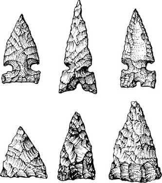
Figure 16 Desert side-notched and cottonwood points. By Tammara Ekness Norton.
In places that were never used for this purpose before. Not surprisingly, obsidian hydration data from the California coast show no evidence that obsidian tools entered the region after about 800 years ago providing additional evidence for the collapse of the earlier commerce between the western Great Basin and populations living west of the Sierra Nevada.
Great Basin archaeologists do not have a clear understanding of why these changes occurred during the Recent Prehistoric period. Some have argued that people living in the Numic homeland (probably the Owens Valley of southeastern California), one of the most arid parts of the basin, developed an adaptation that could deal successfully with the harsh desert conditions in the local area. When the climate deteriorated during the medieval climatic anomaly, making life much more difficult for the Late Archaic and Fremont people, the door was left open for the Numic and their small-group desert adaptation, allowing them to take over much of the Great Basin. The success of this mobile lifeway was clearly evidenced at historic contact, as every habitat was occupied by people using simple but ingenious forms of technology and social organization to make a living in one of the most challenging parts of the North American continent.
See also: Americas, North: American Southwest, Four Corners Region; California and the Sierra Nevada; Plains; Rocky Mountains; Hunter-Gatherers, Ancient.
 World History