The Middle Preceramic site of Paloma, Peril, is one of the most intensively studied sedentary villages from the Middle Holocene of the Americas. The site is situated 3.5 km from the modern beach on an alluvial fan at an elevation of 200 m above mean sea level, just below a fog oasis. Paloma lies 8 km from the Chilca River (Figures 1-3). Frederic Engel conducted the first excavations. The author directed subsequent excavations in four more seasons between 1976 and 1990 in cooperation with Engel, Alice N. Benfer, and Glendon F. Weir.
Paloma presents three important archaeological resources: (1) its preservation of organic materials is good to excellent, (2) its well-stratified deposits show clearly separable village occupations over time, and (3) it was extensively excavated and analyzed. A list of 25 theses and partial list of publications is available at the PalomaWorld web site at Http://coas. missouri. Edu (hereafter, PalomaWorld).
There were excavations of parts of 50 structures, 400 storage pits, 35 hearths, and 201 human interments over four field seasons. A series of 26 radiocarbon dates registers earliest occupation at 7800 BP, with a series of subsequent stratified villages occupied until
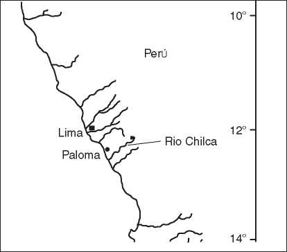
Figure 1 Location of Paloma in Peru; latitude is indicated.
About 4700 BP. The final occupation at Paloma was one in which the population began to relocate to a nearby river valley at the site of Chilca 1.
Paloma is the largest site excavated from this time period; however, Engel has located two other similar, but unexcavated villages, closer to the coast in the same valley. The Paloma site is comprised of oval pit houses, three mortuary structures, and shell middens.
Many structures were in the low shell mounds. A few of the earliest domestic structures at Paloma are small and perhaps do not indicate year-round village sedent-ism. Large, sturdy houses in clusters were widespread by 6500 BP. Figure 4 Shows what a domestic structure (S. 103) looked like during excavation; in it some burial pits and storage pits have been excavated but one storage pit is awaiting excavation. Excavation in this structure, but not in most, continued below the floor to the cut originally made by its builders to create an oval depression for the house.
Design of the Excavation
The design combined two major strategies, a small probability sample of test pits stratified by depth of deposits and extensive lateral excavations (Figure 3). We were surprised to find that domestic structures were buried throughout the alluvial fan, whether there were surface indications or not, and pleased to learn that structures encountered in the probability sample were not distributed differently from those found in lateral excavations. The total excavations were of approximately 2500 m2, which is approximately 10% of the alluvial fan on which the site is situated.
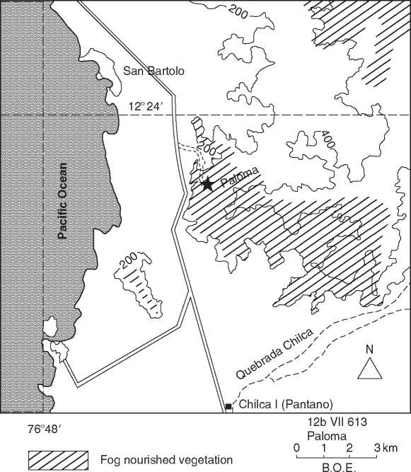
Figure 2 Paloma location in a fog oasis. Map by Bernardino Ojeda E.
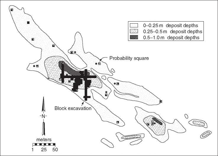
Figure 3 Map of Paloma showing 6 x 6 block excavation in black and smaller probability samples in gray with black subdivision. The sample was stratified by depth of deposits determined by shovel test. Map by B. Ojeda E.
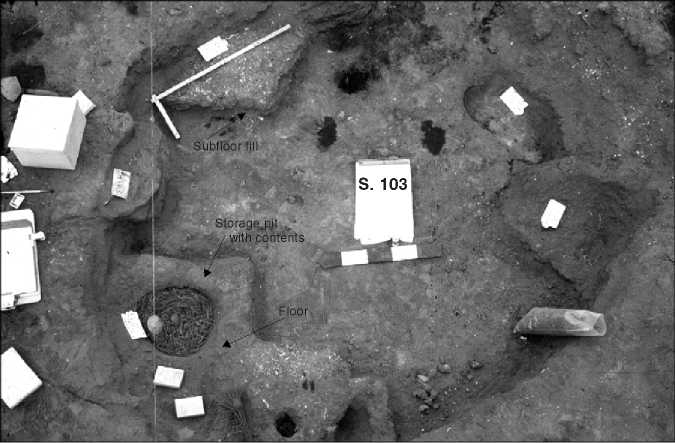
Figure 4 Photograph of S. 103 during excavation; ruler is 1 m.
Stratigraphy
We were able to establish three well-defined strata located throughout the alluvial fan below the fog oasis. Two domestic structures from earlier strata had to be grouped into a single level #400 for the purpose of analysis since they were from strata that were not widely distributed across the site.
Dating
Of 26 radiocarbon determinations, only one did not correspond to the level assigned by our stratigraphy;
Another sample from the same structure did. The three site-wide recognizable zones are dated as follows:
• #100 Reoccupation, 4000 BP. It had rectangular subterranean stone structures and open areas with scattered living areas indicated by midden to the north and east of the Paloma alluvial fan; this occupation is not discussed here.
• #200 4700-5100 BP. A level whose presence was announced by a layer of rotted, often purple, shells, the decay of which suggests abandonment.
• #300 5100-5300 BP. A level topped by thick caliche (calcium carbonate) in areas and always containing more grass than either level above or below; the soil was most often orange in color.
• #400 5300-7800 BP. A level of darker soil containing large hearths.
The earliest date (7800 BP) applies to only a few small structures from nonsite wide strata. The later strata suggest occupations of persistent villages.
 World History