The enormous Mississippi River basin with its hundreds of tributaries and thousands of streams is shaped like a huge tree with a crown 2,000 kilometers across that stretches from the Rockies to the Appalachians. Unlike the Nile, which traverses a desert, or the Amazon, with its extensive rainforest, the Mississippi passes through two contrasting ecological zones; in the west the river transverses mostly open prairie, while in its eastern half it travels through dense woodlands. Only in the Memphis area is the river confined by the foothills of the Ozarks and on the east side by the Memphis Bluffs. But once past this constriction, it proceeds into sandy soil and meanders through a large flood plain, the trunk of the tree, where it is joined by the Arkansas River on its western flank. This immense plain is 70 kilometers wide and 300 kilometers long.
Today, modern levees and concrete banks hold the unruly river within the confines of its bed. In former days, however, during spring and summer, the trunk was less a river than a vast lake reaching down to Natchez, where the flood plain narrowed to about 30 kilometers. By fall, the receding waters would leave behind thousands of square kilometers of marshes and swamps and overlapping ox-bow lakes. Fish, especially large eighty - to ninety-pound catfish, were once common, as were shellfish of various types. Small game and deer populated nearby forests in which one could have found groves of walnut, oak, and pecan trees. Roots and edible plants were plentiful. Twice a year, ducks and geese migrated along the Mississippi corridor by the millions, feeding and resting in lakes and abandoned river loops, making easy targets for hunters (Figure 6.1).
This region, in all its richness, could be compared to the Pacific Coast of Canada or to the Alaskan west coast, for it was one of the great ecological melting pots, as unique and diverse in its own way as even the Amazon River basin. The first people to put roots in this area would have been downright affluent compared to their woodland neighbors to the east, who had to cope with dense forests, and their neighbors to the west, who hunted the recalcitrant buffalo and who had to cope with fierce winter storms. The river also facilitated communication and trade between tribal groups and set the stage for a type of cultural interaction that had never before been seen in these parts. Boat parties acquired desirable materials, stone and metal for ceremonial and prestige purposes, such as Illinois chert for cutting blades, and the red-colored Georgia soapstone for ritual sculptures, while copper was brought from the distant shores of Lake Michigan.
The most important element that differentiated these people from all of the other native peoples in the Americas was that they were mound builders and, as far as we know, the earliest in all of the Americas. Today, in an age of concrete and steel, we can hardly imagine earth as an architectural material. But for thousands of years, people in this part of the world laboriously carried basket loads upon basket loads of earth to designated, sacred sites to create massive landscape-altering
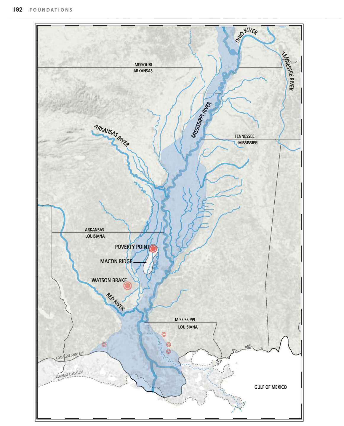
Figure 6.1: Mississippi River flood plain. Source: Florence Guiraud
Structures designed according to specific plans. What prompted this? The hunters in Siberia had no such urge. But the fact remains that relatively quickly, around 4000 bce, long before any such structures were being made in Mexico, mounds were here planned, organized, and designed on a monumental scale.
Mounds varied in size, shape, and layout. Indeed, a remarkable diversity extends throughout the entire mound-building tradition, which spanned some six thousand years. Some mounds were round, some were cone-shaped, some had flat tops, some were long, some had embankments, and others were in the shape of loaves, with long, soft, rounded shapes. The plazas also varied in size, orientation, and design. Though this indicates the relative autonomy of local communities, we have to look less at the mounds themselves than at the underlying geometry that seems to have gone into their planning and layout.1 But how that geometry was achieved, whether by a series of triangulations or by other means, is not known. It has often been held that the mounds were platforms for temples or sacred structures on their summit and that the mound was simply a way to elevate the temple. But this was probably not the case early on when the mound itself represented “the temple.” Structures, if there were any, may have supported the activities on the mound, but were not themselves “the temple.”2
Though today we see the mound as a passive object in the landscape, most mounds were constructed in phases over the entire period of the community’s existence, growing in height and width over time. In fact, just as the mound was important to the community, so too was the act of sealing the previous mound under the mantle of the new layer. This “burial” was understood as a renewal of the world and as an act of purification. It was a deep-seated tradition that extends even to the great Mayan pyramids in Mexico, where one construction was built directly over an earlier temple, completely entombing it in the new. But in North America, neither mounds nor plazas were ever made of stone or adobe as was the case in Mesoamerica and Peru. We should not assume, however, that the jump to stone was an indication of a more advanced architectural thought. For the North American builders, mounds were not heaps of dirt, but consisted of difierent types of soil, and were often of difierent colors. Though the mounds that still exist today are covered with grass, this would not originally have been the case. Some were covered with red clay, others were white, some were striped, and some were red on the top and black on the sides. Clay is vulnerable to erosion, and regardless of how well compacted it was, the mounds began to erode over the years, especially in the rainy climate of the south. This might have been a contributing factor in the call for renewal. But what do the colors mean?
From ethnographic studies we know that First Society notion of color is far difierent from modern views. Color was intertwined with symbolic, geographic, and cosmological significances. Whiteness was often associated with well-being, cognition, and spiritual enlightenment; blackness with death and the spirit world, and redness with the vitality of life. But color was also directly related to the horizontal and vertical dimension of shamanistic universe, where it is not the singularity of the colors that is important, but their combination and particular sequencing. For the Southeast tribes in Georgia and Mississippi, the dichotomy of red and white was particularly deeply rooted, associated with ochre and bones, as well as with various directions of the compass.
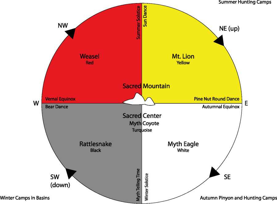
For the Utes, who live in Colorado and Utah, the main colors were turquoise, red, yellow, white, and black. The sky is considered white, the mountains yellow, the basins red, the underworld black, and the mountainside turquoise. Colors were also related to the seasons: spring is red and relates to the northwest, summer is yellow and relates to the northeast, autumn is white and relates to the southeast, and winter is black and relates to the southwest. White is the most important (eagle), then yellow (mountain lion), turquoise (wolf), red (weasel), and black (rattlesnake). Colors also have powers. Since red symbolizes the weasel, Utes will paint their moccasins red since weasels can kill a rattlesnake. In this way the red paint protects its wearer from the snake3 (Figures 6.2 and 6.3).
Sky | Eagle (Zenith) | White |
Upper Earth | Mountain Lion | Yellow |
Center Earth | Wolf | Green-Gray-Blue |
Lower | Weasel | Red |
Rattlesnake | ||
The Underworld | (Nadir) | Black |
Figure 6.2: Ute color theory drawing. Source: Timothy Cooke/James A. Goss, "Traditional Cosmology, Ecology and Language of the Ute Indians," in Ute Indian Arts and Culture: From Prehistory to the New Millennium, edited by William Wroth (Colorado Springs: Taylor Museum of the Colorado Fine Arts Center, 2000), 47-49
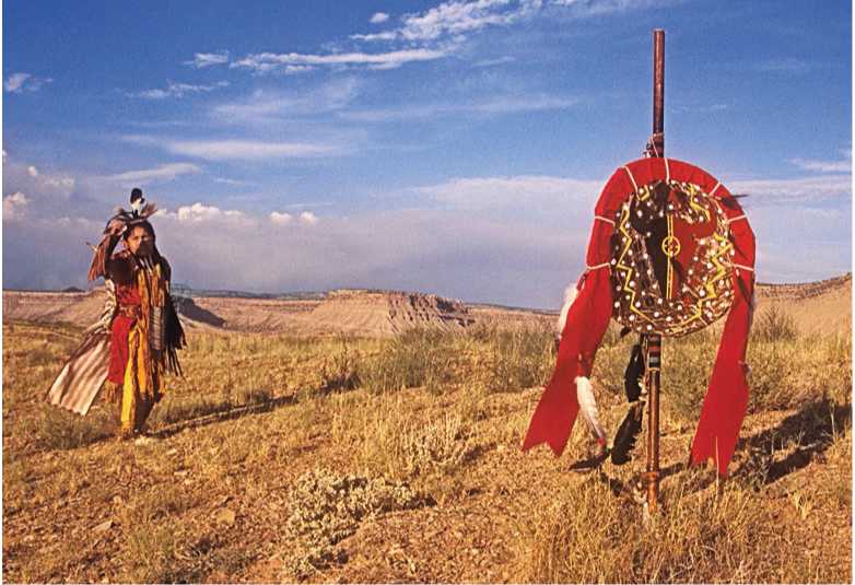
Figure 6.3: Ute ceremonial dance with spirit post, Colorado. Source: Suzi McGregor
The meaning of the color scheme used in any one particular mound is lost to us, but one thing is sure, mounds could never have been made in stone, for it was precisely the soil as building material and coloring agent that was significant. Even for the Olmecs, Mayans, and all the way to the Incas, color was more than just a surface treatment, but a messenger of the spirit world. The stone buildings of the Mayans have lost most of their paint and we can only guess at how vibrant they must have once appeared. In North America, we have a better sense of the color since we can see the difierent-colored clays.
No less amazing than the mounds were the plazas in front of them. They were the sites where social, political, and economic alliances were forged, and where coming-of-age and initiation rites and dances were performed. Though they had to accommodate a large number of people, they may have been the site of special, ritual constructions. They were also ritually cleaned before major events; they were swept and smoothed out. The mound-and-plaza combination constituted the center of tribal cohesion. Each community may have had a home mound-and-plaza area, but people most certainly visited other ceremonial centers and in the process created an interconnected boat-based system in which religion, trade, and ceremony overlapped.
One has to imagine a vibrant life around these places. The shaman or clan head and his retinue lived close by; in various clusters, one would have found the residential areas, traces of which have all but disappeared. Reed and thatch houses do not last more than a few years unless rebuilt.
40 03 15 N, 82 26 36 W
Of the many thousands of mounds and plazas that were eventually built along the waterways of the Mississippi and its numerous tributaries, few still exist today. A dozen or so are national landmarks. Even where a mound may have been preserved, the plaza has largely disappeared as a grassy field and is perhaps used as a parking lot. The decline of the river cultures in the fifi:eenth century meant that many of these sites were, in fact, no longer in use when the Europeans arrived and were already overgrown. It is probably safe to assume that only a fraction of 1 percent of the ancient mounds and plazas has survived into modern times. Apart from those that have been preserved, some remain as strange, ghostly shapes in the earth when viewed afi:er a frost from an airplane. Most were plowed under or lost beneath the streets and buildings of cities, their memories lost, while others were assumed to be natural formations. The plaza-enclosure of Newark Mound in Ohio, which was once one of the greatest ritual centers in all of North America, is now a golf course! And in this, it has, astonishingly, fared better than many.
The so-called Big Mound of St. Louis was destroyed in the 1860s to make way for an expansion of the city. But there were other reasons for its destruction, for even as late as the nineteenth century, the site continued to be visited by Native Americans. On one occasion, according to a
38 38 31 N, 90 11 10 W
Figure 6.4: Marker for Big Mound, St. Louis, Missouri. Source: Beth Wiltsch
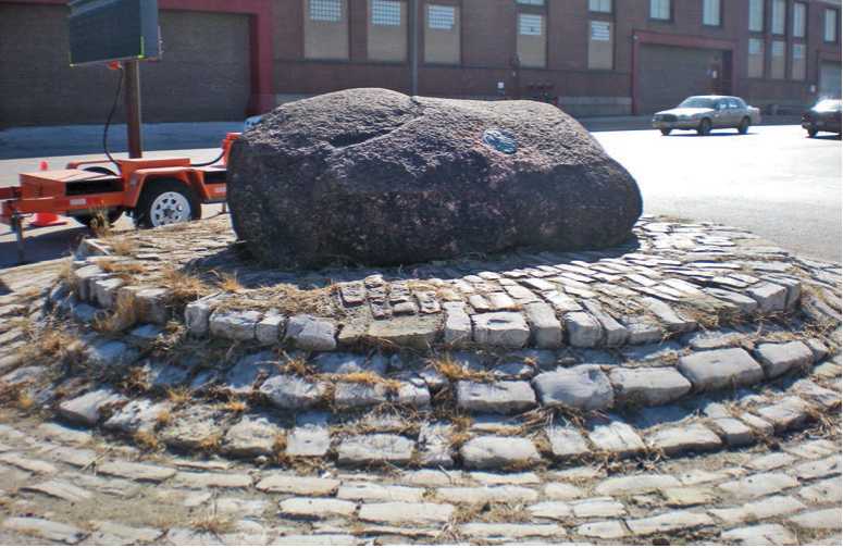
Report in the mid-1820s, a chief who happened to die nearby was buried on the top of the mound and Indians would come regularly to freshen up the memorial and set up a post at the head of a grave painted red.4 Removing the mound thus removed the Indians. Today, only a strange-looking and perhaps once sacred rock is left to mark the spot of the former mound; it sits forlorn and unidentified in the middle of a traffic intersection (Figure 6.4). Fortunately, already in the nineteenth century, some intrepid observers noted the presence of these mounds, and drew and described them, and eventually a few were saved. In 1817, one observer of the Cahokia mounds wrote:
The prospect from this mound is very beautiful; looking towards the blufi's, which are dimly seen at the distance of six or eight miles, the bottom at this place being very wide, I had a level plain before me, varied with islets of wood and a few solitary trees; to the right the prairie is bounded by the horizon, to the left, the course of the Cahokia [river] may be distinguished by the margin of wood upon its banks, and crossing the valley diagonally south-southwest. Around me I counted twenty mound or pyramids, beside a great number of small artificial elevations; these mounds form something more than a semicircle, about a mile in extent, its diameter formed by the river. . . . Although it might not have been a Licopolis, Persepolis, or Thebes, it is not improbable that it contained many thousand inhabitants. This plain, now reposing in the stillness of death, was once the scene of a busy and crowded population; those temples now devoted to the idolaters of silence, once resounded with shouts of war or the songs of peace. 5


 World History