Northern South America comprises a diverse and varied tropical landscape that extends from the island of Trinidad in the east to the Pacific shores of Colombia and Ecuador (Figure 1). The northern coast is bathed
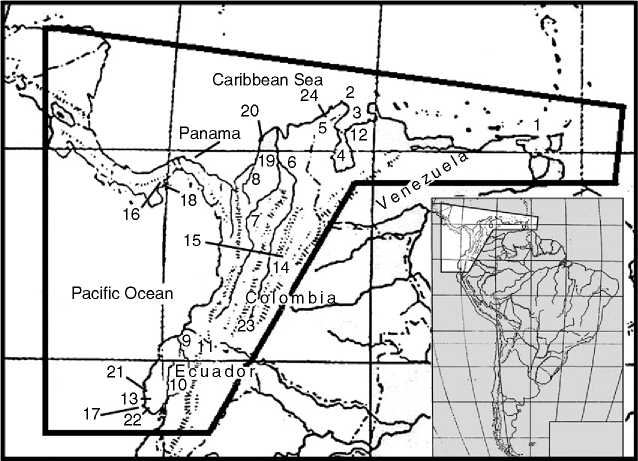
Figure 1 Map of northern South America. The following correspond to the numbers on the map: 1, Paria Peninsula; 2, Goajira Peninsula; 3, Gulf of Venezuela; 4, Lake Maracaibo; 5, Sierra de Santa Marta; 6, Magdalena River; 7, Cauca River; 8, Sinu River; 9, Esmeraldas River; 10, Guayas River; 11, El Inga; 12, Taima Taima; 13, Las Vegas; 14, Bogotfj; 15, El Abra; 16, Santa Maria Valley; 17, Santa Elena Peninsula; 18, Cerro Mangote& Monagrillo; 19, San Jacinto 1 & San Jacinto 2; 20, Puerto Hormiga; 21, Valdivia; 22, Real Alto; 23, San Agusttn; 24, Tairona culture.
By the Caribbean Sea and backed across northern Venezuela by an eastward extension of the Andes mountains, which embrace a series of fertile highland valleys. From the Paria Peninsula in the east to the Goajira Peninsula in the west the Caribbean coast is a semi-arid desert, the native vegetation consisting mainly of cactus and thickets of thorny shrubs and trees. The Gulf of Venezuela, which opens onto the Caribbean near the Colombian frontier, connects to the south with Lake Maracaibo, South America’s largest lake, which is surrounded by tropical forests, savanna grasslands, and swamps. Rising more than 6000 m above the Goajira Peninsula stands the Sierra de Santa Marta, snow-topped mountains with a vista of the Caribbean. To the west lie the extensive alluvial lowlands of northern Colombia, comprising swamps, lakes, savannas, forests, and dissected by the lower courses of the Magdalena, Cauca, and Sintf Rivers. The landscape rises again in northwestern Colombia where a low chain of the Andes extends northward to form the Isthmus of Panama. This region, where North America meets South America, is the wettest part of the Western Hemisphere, with annual rainfall ranging between 6 and 8 m. Heavy rainfall, with associated forests, lagoons, and swamps, continues south along the Pacific coast to the central littoral of Ecuador, where drier conditions prevail (see Americas, Central: Lower Central America).
The interior of western Ecuador is a wet tropical lowland region, dominated by two river systems, the
Esmeraldas River in the north and the larger Guayas in the south. The Andes in Ecuador form a narrow chain, trending north-south, punctuated by a series of highland basins and snowcapped volcanoes. Tropical forests cover the mountain slopes to the west and to the east. Passing north into Colombia, the Andes are divided into three separate chains by the Cauca and Magdalena River Valleys. The eastern chain contains the high grassland region known as the Sabana de Bogotii and continues eastward into Venezuela.
 World History