While specific categories of applied technology are transitory and often rapidly obsolete, often sometimes with longevity of no more than six months to a year, the underlying ‘strategies and capabilities’ have been consistently applied with little alteration by the author, initially to address discoveries under construction and then later for archaeological investigation in toxic and hazardous environments. In addition to a ‘core’ of basic
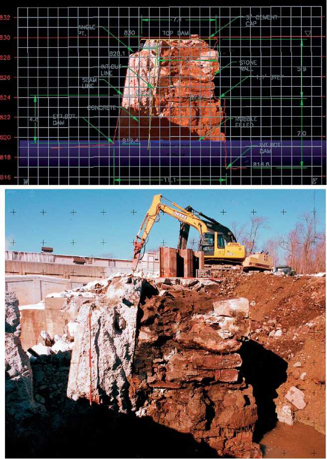
Figure 13 2003-04/Stanhope, New Jersey. (Bottom) Metric photo of sectioned historic dam profile, captured with Rolleimetric camera as the historic dam was sectioned and impounded river water was released to unblock the flood-damaged channel. Note the imbedded calibration marks used to correlate metric photograph with real-world coordinates recorded by the laser-radar. (Top) Digital composite of Rolleimetric photo of cross-section of 1830-era cut-stone dam - the metric photo is scaled, overlaid, and geo-referenced to LIDAR-derived elevation and dimension profile measurements. © 2007 Joel W. Grossman, PhD. Published by Elsevier Inc. All rights reserved.
Archaeological techniques, the investigation of dangerous and/or toxic contexts has consistently relied upon a common set of strategic and logistical approaches and toolkits: (1) the use of geospatial procedures to control existing conditions and provide historic map correlations as well as for the evaluation of terrestrial geophysics to target buried resources, (2) on-site concurrent laboratory data control and conservation, (3) highspeed remote and non-contact 3D recording systems, (4) all-weather environmental control systems, (5) self-contained power, dewatering, heat, and communication systems, (6) adherence to HAZMAT health and
Safety procedures, through on-site decontamination of artifacts and staff when required, and finally (7) the precondition that all archaeological tasks be defined by highly resolved task-specific budgets, pre-authorized to include data-derived benchmarks, or triggers (e. g., concurrent laboratory-derived increments in artifact totals) for seamless changes in projected levels of effort and budget allocation.
In addition to these shared characteristics, both of the cases presented here demonstrate the integration of a range of applied technology solutions in order to facilitate the safe and rapid investigation of logistically challenging, contaminated or dangerous archaeological settings. The West Point case also proves that the profession of archaeology is able to operate in tandem, and in full compliance, with existing Superfund regulations and constraints, in the context of dangerous or toxic environments and without scientific compromise. The success of the archaeological rescue effort in Stanhope underscores the emerging ability of modern archaeology and new technologies of site recording to jointly do justice to important cultural resources, to the highest standards of the US Department of Interior, even in the face of restricted time frames and difficult conditions. It also demonstrates the ability to mobilize, plan and resolve archaeological emergencies in tight coordination with ongoing emergency repair or rescue activities, under extreme weather conditions and without delay.
At the policy level, the near-total data control provided by the new generation of 3D geospatial recording technologies present cost-effective alternatives to traditional methodological impediments to implementing historic preservation mandates in hazardous situations or natural disasters. Finally, these new, and constantly improving, capabilities also now suggest that the old Hobson’s choice (a choice that is not a real choice) of ‘history versus progress or’, in this case, ‘history versus natural’ disaster, may no longer apply.
 World History