The northeast of Ireland rose to become one of the wealthiest areas not only in Ireland, but also in the English and European Atlantic world. It had a fertile soil and was close to stones of various types as well as to copper and other resources. At an early phase the west bank of the River Boyne about 5 kilometers inland was set aside as a ritual zone, and it soon became the site of one of the grandest structures ever built, Newgrange (3200 bce). Unlike the smaller Carrowmore tombs, this one was an engineering feat of major proportions (Figures 10.35a, 10.35b, 10.35c and 10.36a, 10.36b, 10.36c, 10.36d). The tomb sits on an area where the River Boyne makes a distinctive loop. The site also overlooks the spot where the tide reaches its highest along the River Boyne, meaning that the area probably served as a port. Perhaps this place where the river meets the sea was seen as a fitting metaphor for the location where the living commune with the dead.
It is 79 by 85 meters in circumference with 97 large kerbstones delimiting its perimeter.41 It was made of 200,000 tons of stones and was flat topped, perhaps to serve as a ritual platform. There is some evidence that there was a standing stone at the top. How the stones were brought to the site is not known, but most likely they were transported by boat down the river. Many of the stones were elaborately ornamented with circles, spirals, and swirls. The front of the mound was decorated with small quartz stones. In the 1970s, these were built up in the form of a concrete-reinforced wall. But it is unlikely that this was the situation in ancient times since such a wall would have been highly unstable. The shape of the mound would have been gentler. The sparkling white stones, which were brought from a mountain to the south, were possibly ritual stones thrown onto the mound, creating a shimmering efiect in a moonlit ceremony.
The mound has a 19-meter-long, stone-lined passage that leads to a three-lobed chamber. The passage is not straight, but designed with some slight twists. It also slopes gently upward and under a stone-lined, light box that allows a sliver of light to penetrate to the back of the chamber during solstice. The edge of the top stone of the light box is decorated with an X-shaped motif. The rear chamber is small and built only for the priests who performed the sacred rites. It is a unique and daring design, for as one moves into the chamber, one does not see the light box, though certainly the priests knew about it. Many of the stones of the inner chamber are decorated with spirals, circles, and zigzags. Tests indicate that the chamber is well suited to male chanting, but what the rituals consisted of is unknown.
To understand the construction, one has to think backward. First the line of the sun had to be secured, which could only have taken place during the winter solstice. This line was somehow preserved during the years of construction with builders lifi:ing and manipulating the heavy stones without being able to test the results of their efiort. Meanwhile, work was underway on the mound, which was begun to the right and left: of the structure, so that by the time the stones were set they were sitting in a type of valley. Once the stone work was done, the valley was mounded over with tons of stones and dirt to complete the hill. Since one of the main concerns was that dirt could slip down the slope, the builders added several compact layers of clay. How long it took to complete is anyone’s guess, maybe ten or twenty years.
The structure did not last long. It seems that a century or so afi:er construction, the earth from the mound did indeed slide down and partially obscure the entrance and light box. Nonetheless, the site continued to be important for another thousand years, with wooden circles and tombs of various sorts constructed nearby and adding to its sanctity.
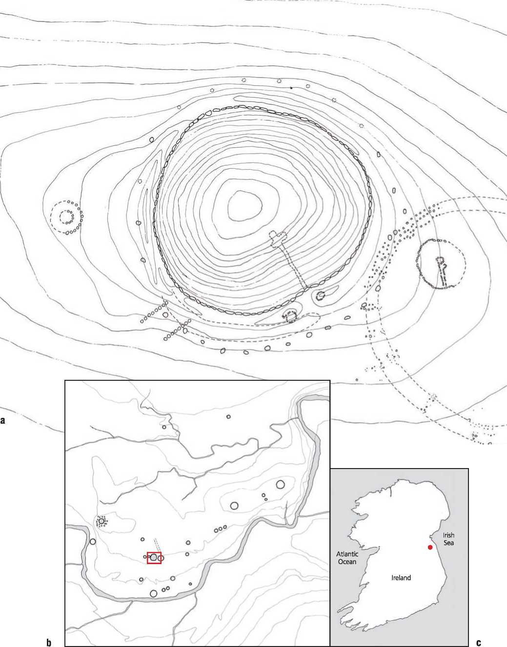
Figure 10.35a, b, c: Newgrange, Ireland: (a) plan; (b) site plan; (c) map. Source: Timothy Cooke/Geraldine Stout and Matthew Stout, Newgrange (Cork: Cork University Press, 2008), 46
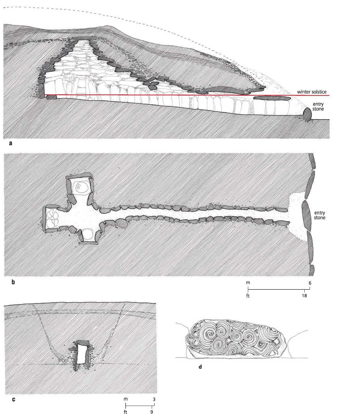
Figure 10.36a, b, c, d: Newgrange, Ireland: (a) longitudinal section; (b) plan; (c) cross section; (d) detail of entrance stone. Source: Timothy Cooke/Geraldine Stout and Matthew Stout, Newgrange (Cork: Cork University Press, 2008), 46
 World History