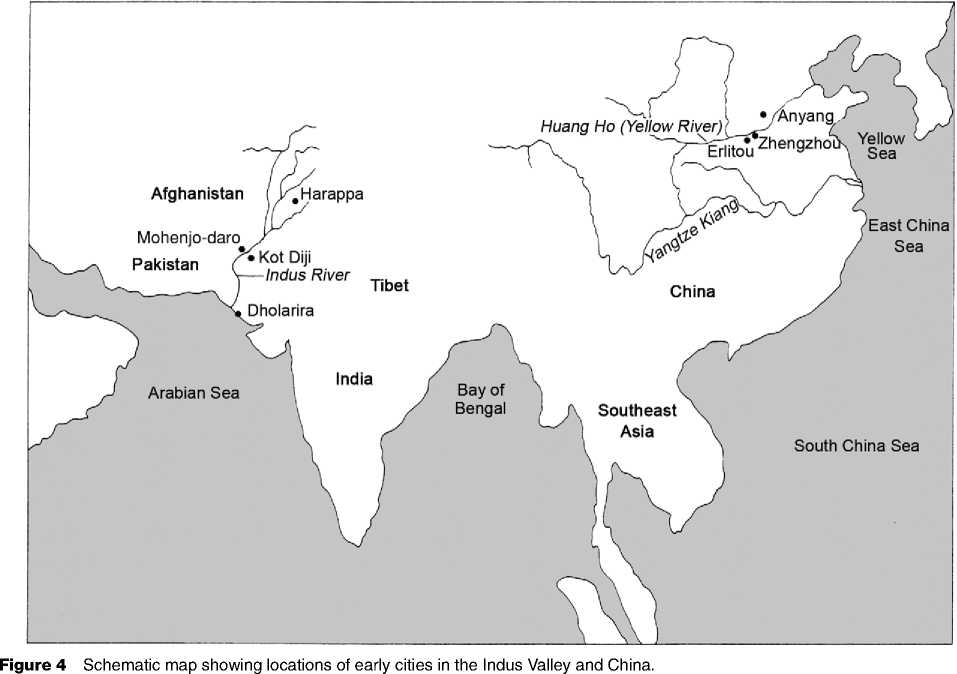
The early Indus civilization covered a vast area of 500 000 km2 and extended well beyond the Indus River basin to parts of Afghanistan in the north and to Gujarat in the south to the Indo-Gangetic divide in

The east and the Makran coast in the west (Figure 4). The early cities of the Harappan phase of the Indus Valley Tradition of Pakistan and western India developed by 2600 BC and lasted as late as 1300 BC in some areas. The region was not politically unified and the degree of integration of Harappan centers is debated. At least five centers were large enough to be considered cities: Harappa, Mohenjo-daro, Dholavira, Ganweriwala, and Rakhigarhi, each with a hinterland of 100 000-150 000 km2. All Indus cities shared some common features: walled settlements, urban planning of streets and buildings, sophisticated drainage systems, a common writing system and system of weights, and similar styles of pottery and other goods (see Asia, South: Indus Civilization).
The nature of urban-rural integration is not well understood. Some archaeologists have even questioned whether early Indus polities were states because of an absence of monumental religious architecture, palaces, and depictions of rulers and limited evidence of warfare. The Great Bath at Mohenjo-daro indicates that ritual bathing has a long religious tradition in the region. The lack of glorification of rulers is not unique among early civilizations and suggests a corporate form of rulership. The absence of recognized archaeological evidence of warfare does not necessarily indicate an absence of warfare, as the history of research on Classic Maya civilization demonstrates. The size, complexity, and urban planning of Indus cities are consistent with the state form of organization.
The Indus script is yet to be deciphered. Recent archaeological investigations, however, have provided new details of Indus cities and also corrected misconceptions from their initial discovery in the 1920s.
Harappa
The city of Harappa was first settled around 3300 BC and expanded to cover at least 150 ha. The urban population ranged from 40 000 to 80 000 persons, depending on the time of year. Four mounded areas were clustered around a central depression that might have held water. The mounded areas were walled, as was the entire city, and entered by gateways. Because of poor preservation, it is difficult to determine the layout of houses and the function of buildings. Workshops occur along with residences in each of the mounded areas. Various functions for the walls have been suggested: defense, flood control, and the demarcation of sociopolitical boundaries. Workshops and multistory residences built of kiln-fired bricks occur in all the mounded areas, suggesting that the walls may represent political and/or social divisions, along with defensive aspects. The city was laid out to separate public and private areas.
Indus cities had sophisticated water - and waste-management systems. Wells for drinking water occurred in and around Harappa. Houses had bathing areas, latrines, and sewers that connected to larger drains that emptied beyond the city walls. The fertile waste water was deposited on agricultural fields surrounding the city.
Mohenjo-daro
Mohenjo-daro, located on the lower Indus, is the best-preserved Indus city. It covers 200 ha. The walled citadel mound includes several large buildings that might include elite residences, along with the famous Great Bath. A lower town covering 8 ha is divided by four major east-west and north-south streets that divide into blocks that are further subdivided by smaller streets and alleyways. Houses are grouped around courtyards and included bathrooms and elaborate drainage systems. Workshops where various types of commodities were produced are distributed throughout the city.
Dholavira
Dholavira is the most recently discovered Harappan city. It is located on Kadir Island in the Gulf of Kutch and was founded as an outpost or colony. The mix of artifact styles suggests that along with the local population, Indus Valley elites and artisans lived in the city. Dholavira had a very different layout than the better-known cities of Mohenjo-daro and Har-appa. The outer city wall enclosed a series of walled rectangular and square compounds. Residential and craft areas occurred in the lower or outer town that is divided by streets running in cardinal directions. Large structures were present on the acropolis.
Little excavation has been undertaken at either Rakhigarhi or Ganweriwala, two cities identified through survey. Much work remains to be done to understand early Indus cities more thoroughly. The cities were connected through trade networks. They imported raw materials and finished goods form Central Asia and Afghanistan, and carnelian beads and shell bangles made in Indus cities have been found in Mesopotamia and Central Asia.
Around 1900 BC, the cities began to lose population, and other defining characteristics of early Indus civilization such as its system of weights were no longer practiced. Foreign invasions, natural disasters, and disruption of trade networks with southwest Asia used to be the conventional explanations, but archaeologists now favor an interaction of factors that might have disrupted trade networks and undermined the power of elites, but the details remain unclear.


 World History


